Isle Royale
Island in Lake Superior in Michigan, United States of America / From Wikipedia, the free encyclopedia
Dear Wikiwand AI, let's keep it short by simply answering these key questions:
Can you list the top facts and stats about Isle Royale?
Summarize this article for a 10 year old
Isle Royale (/ˈrɔɪəl/, ROY-əl)[1] is an island of the Great Lakes located in the northwest of Lake Superior and part of the U.S. state of Michigan. The island and the 450 surrounding smaller islands and waters make up Isle Royale National Park.
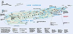
 Map of Isle Royale | |
| Geography | |
|---|---|
| Location | Lake Superior |
| Coordinates | 48°0′N 88°55′W |
| Area | 206.73 sq mi (535.4 km2) |
| Length | 45 mi (72 km) |
| Width | 9 mi (14 km) |
| Highest elevation | 1,394 ft (424.9 m) |
| Highest point | Mount Desor |
| Administration | |
United States | |
| State | Michigan |
| County | Keweenaw County |
| Townships | Eagle Harbor / Houghton |
| Demographics | |
| Population | 0 (2000) |
Isle Royale is 45 miles (72 km) long and 9 miles (14 km) wide, with an area of 206.73 square miles (535.4 km2), making it the fourth-largest lake island in the world. In addition, it is the largest natural island in Lake Superior, the second-largest island in the Great Lakes (after Manitoulin Island), the third-largest in the contiguous United States (after Long Island and Padre Island), and the 33rd-largest island in the United States.[2]
Isle Royale is defined by the United States Census Bureau as Census Tract 9603 of Keweenaw County, Michigan (a county found in the state's Upper Peninsula). As of the 2000 census there was no permanent population on Isle Royale.[3] After the island was made a national park, some existing residents were allowed to stay,[4] and a few leases are still in effect.
