Mumbai City district
District of Maharashtra in India / From Wikipedia, the free encyclopedia
Dear Wikiwand AI, let's keep it short by simply answering these key questions:
Can you list the top facts and stats about Mumbai City district?
Summarize this article for a 10 year old
SHOW ALL QUESTIONS
Mumbai City district is a district of Maharashtra in Konkan Division, India. As a city district, it has no headquarters or subdivisions. It, along with the Mumbai Suburban District, makes up the metropolis of Mumbai. This area is called the "Island City" or South Mumbai or Old Mumbai. It extends from Colaba in the south to Mahim and Sion in the north. The city has an area of 157 km2 (61 sq mi) and a population of 3,085,411.[1]
Quick Facts Country, State ...
Mumbai City district | |
|---|---|
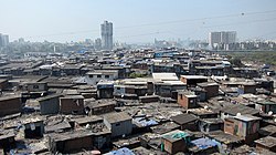
Clockwise from top-left: Gateway of India, South Bombay Harbour, Chaitya Bhoomi, Dharavi, Taj Mahal Palace Hotel | |
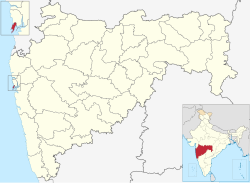
 Location in Maharashtra | |
| Coordinates: 18.96°N 72.82°E / 18.96; 72.82 | |
| Country | India |
| State | Maharashtra |
| Division | Konkan |
| Government | |
| • Body | Brihanmumbai Municipal Corporation |
| • Guardian Minister | Deepak Kesarkar (Cabinet Minister MH) |
| • Mayor |
|
| • District Collector |
|
| • Municipal Commissioner & Administrator |
|
| • MPs | |
| Area | |
| • Total | 71 km2 (27 sq mi) |
| Population (2024) | |
| • Total | 3,304,000 |
| • Density | 47,000/km2 (120,000/sq mi) |
| Time zone | UTC+5:30 (IST) |
| Sex ratio | 840 |
| Literacy | 89.2% |
| Website | https://mumbaicity.gov.in/ |
Close


