Pitcairn Island is the only inhabited island of the Pitcairn Islands, in the southern Pacific Ocean, of which many inhabitants are descendants of mutineers of HMS Bounty.[1]
 Satellite image | |
 Pitcairn Island Location of Pitcairn Island | |
| Geography | |
|---|---|
| Location | Pacific Ocean |
| Coordinates | 25°04′00″S 130°06′24″W |
| Archipelago | Pitcairn Islands |
| Area | 4.5 km2 (1.7 sq mi) |
| Length | 3.5 km (2.17 mi) |
| Width | 1.8 km (1.12 mi) |
| Highest elevation | 346 m (1135 ft) |
| Highest point | Pawala Valley Ridge |
| Administration | |
United Kingdom | |
| Demographics | |
| Population | 40 (2024) |
| Pop. density | 10/km2 (30/sq mi) |
Geography
The island is of volcanic origin, with a rugged cliff coastline. Unlike many other South Pacific islands, it is not surrounded by coral reefs that protect the coast. The only access to the island is via a small pier on Bounty Bay. Adamstown is the sole settlement.
Pawala Valley Ridge is the island's highest point at 346 m above sea level.
The volcanic soil and tropical climate with abundant rainfall make the soil productive.
The average temperature ranges from 19 to 24°C. The annual rainfall is 1,800 mm. [citation needed]
Fauna
Indigenous fauna consists of insects and lizards. Since their introduction, rats have become an invasive species.
A large number of seabirds nest along the steep shorelines.[2]
As coral reefs are absent, fishing is offshore. Sharks, sea bream, barracudas and tuna are all abundant. Whale migrations are seen yearly.
History and population
Gallery
 Church
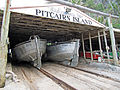 Longboats
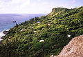 View of Adamstown
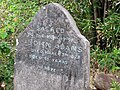 John Adams's grave
 Pier
Pier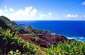 St Paul’s Point (east coast)
 Indigenous vegetation at Garnets Ridge
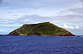 Southwest
 St Paul’s pool


See also
References
External links
Wikiwand in your browser!
Seamless Wikipedia browsing. On steroids.
Every time you click a link to Wikipedia, Wiktionary or Wikiquote in your browser's search results, it will show the modern Wikiwand interface.
Wikiwand extension is a five stars, simple, with minimum permission required to keep your browsing private, safe and transparent.