Geology describes the structure of the Earth on and beneath its surface and the processes that have shaped that structure. Geologists study the mineralogical composition of rocks in order to get insight into their history of formation. Geology determines the relative ages of rocks found at a given location; geochemistry (a branch of geology) determines their absolute ages. By combining various petrological, crystallographic, and paleontological tools, geologists are able to chronicle the geological history of the Earth as a whole. One aspect is to demonstrate the age of the Earth. Geology provides evidence for plate tectonics, the evolutionary history of life, and the Earth's past climates.
The geology of the Grand Canyon area includes one of the most complete and studied sequences of rock on Earth. The nearly 40 major sedimentary rock layers exposed in the Grand Canyon and in the Grand Canyon National Park area range in age from about 200million to nearly 2billion years old. Most were deposited in warm, shallow seas and near ancient, long-gone sea shores in western North America. Both marine and terrestrial sediments are represented, including lithified sand dunes from an extinct desert. There are at least 14 known unconformities in the geologic record found in the Grand Canyon.
Uplift of the region started about 75million years ago during the Laramide orogeny; a mountain-building event that is largely responsible for creating the Rocky Mountains to the east. In total, the Colorado Plateau was uplifted an estimated 2 miles (3.2km). The adjacent Basin and Range Province to the west started to form about 18million years ago as the result of crustal stretching. A drainage system that flowed through what is today the eastern Grand Canyon emptied into the now lower Basin and Range province. The opening of the Gulf of California around 6 million years ago enabled a large river to cut its way northeast from the gulf. The new river captured the older drainage to form the ancestral Colorado River, which in turn started to form the Grand Canyon. (Full article...)
Image 2
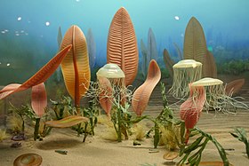
Life in the Ediacaran Period, as imagined by researchers in 1980. The Ediacaran (/ˌiːdiˈækərən/; formerly Vendian) biota is a taxonomic period classification that consists of all life forms that were present on Earth during the Ediacaran Period (c.635–538.8 Mya). These were enigmatic tubular and frond-shaped, mostly sessile, organisms. Trace fossils of these organisms have been found worldwide, and represent the earliest known complex multicellular organisms. The term "Ediacara biota" has received criticism from some scientists due to its alleged inconsistency, arbitrary exclusion of certain fossils, and inability to be precisely defined.
The Ediacaran biota may have undergone evolutionary radiation in a proposed event called the Avalon explosion, 575million years ago. This was after the Earth had thawed from the Cryogenian period's extensive glaciation. This biota largely disappeared with the rapid increase in biodiversity known as the Cambrian explosion. Most of the currently existing body plans of animals first appeared in the fossil record of the Cambrian rather than the Ediacaran. For macroorganisms, the Cambrian biota appears to have almost completely replaced the organisms that dominated the Ediacaran fossil record, although relationships are still a matter of debate. (Full article...)
Image 3
Map showing location of epicenter of earthquake relative to Ambato; the bullseye is the epicenter; small blue lines are rivers
The 1949 Ambato earthquake was the deadliest earthquake in the Western Hemisphere in five years. On August 5, 1949, it struck Ecuador's Tungurahua Province southeast of its capital Ambato and killed 5,050people. Measuring 6.4 on the Ms scale, it originated from a hypocenter 15km beneath the surface. The nearby villages of Guano, Patate, Pelileo, and Pillaro were destroyed, and the city of Ambato suffered heavy damage. The earthquake flattened buildings and subsequent landslides caused damage throughout the Tungurahua, Chimborazo, and Cotopaxi Provinces. It disrupted water mains and communication lines and opened a fissure into which the small town of Libertad sank. Moderate shaking from the event extended as far away as Quito and Guayaquil.
Earthquakes in Ecuador stem from two major interrelated tectonic areas: the subduction of the Nazca Plate under the South American Plate and the Andean Volcanic Belt. The 1949 Ambato earthquake initially followed an intersection of several northwest-southeast-trending faults in the Inter-Andean Valley which were created by the subduction of the Carnegie Ridge. Strata of rock cracked as the earthquake ruptured the faults, sending out powerful shock waves. Today threats exist throughout the country from both interplate and intraplate seismicity. (Full article...)
Image 4
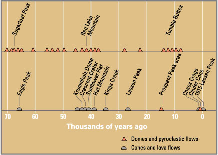
Eruptions in the Lassen volcanic area in the last 70,000 years. Circle shows base of Mount Tehama. See timeline image.
Between 3 and 4 million years ago, volcanic-derived mud flows called lahars streamed down several major mountains that included nearby but now extinct Mount Yana and Mount Maidu to become the Tuscan Formation. Basaltic and later andesitic to dacitic flows of lava covered increasingly larger areas of this formation to eventually form the lava plateau upon which the park is situated. About 600,000 years ago, Mount Tehama started to rise as a stratovolcano in the southwestern corner of the park, eventually reaching an estimated 11,000ft (3,400m) in height. (Full article...)
Image 5
Artist's concept of the Earth 5–7.5 billion years from now, when the Sun has become a red giant
While the future cannot be predicted with certainty, present understanding in various scientific fields allows for the prediction of some far-future events, if only in the broadest outline. These fields include astrophysics, which studies how planets and stars form, interact, and die; particle physics, which has revealed how matter behaves at the smallest scales; evolutionary biology, which studies how life evolves over time; plate tectonics, which shows how continents shift over millennia; and sociology, which examines how human societies and cultures evolve.
These timelines begin at the start of the 4th millennium in 3001 CE, and continue until the furthest and most remote reaches of future time. They include alternative future events that address unresolved scientific questions, such as whether humans will become extinct, whether the Earth survives when the Sun expands to become a red giant and whether proton decay will be the eventual end of all matter in the Universe. (Full article...)
Image 6
The 2002 Bou'in-Zahra earthquake (also known as the 2002 Avaj earthquake or the 2002 Changureh earthquake) occurred on 22 June 2002. The epicenter was near the city of Bou'in-Zahra in Qazvin Province, a region of northwestern Iran which is crossed by several major faults that is known for destructive earthquakes. The shock measured 6.5 on the Mwc scale, had a maximum Mercalli intensity of VIII (Severe), and was followed by more than 20 aftershocks. At least 230 people were killed and 1,500 more were injured.
According to the International Institute of Earthquake Engineering and Seismology (IIEES), the earthquake was felt as far away as the capital city of Tehran, approximately 290 kilometres (180mi) east of the epicenter, although no damage was reported there. Most houses in the region were single-story masonry buildings, and virtually all of these collapsed. The public became angry due to the slow official response to victims who needed supplies. Residents of the town of Avaj resorted to throwing stones at the car of a government minister. (Full article...)
Because the arrangement of atoms in diamond is extremely rigid, few types of impurity can contaminate it (two exceptions are boron and nitrogen). Small numbers of defects or impurities (about one per million of lattice atoms) can color a diamond blue (boron), yellow (nitrogen), brown (defects), green (radiation exposure), purple, pink, orange, or red. Diamond also has a very high refractive index and a relatively high optical dispersion. (Full article...)
The epoch is bracketed by two major events in Earth's history. The K–Pg extinction event, brought on by an asteroid impact (Chicxulub impact) and possibly volcanism (Deccan Traps), marked the beginning of the Paleocene and killed off 75% of species, most famously the non-avian dinosaurs. The end of the epoch was marked by the Paleocene–Eocene Thermal Maximum (PETM), which was a major climatic event wherein about 2,500–4,500 gigatons of carbon were released into the atmosphere and ocean systems, causing a spike in global temperatures and ocean acidification. (Full article...)
The eruption was preceded by a two-month series of earthquakes and steam-venting episodes caused by an injection of magma at shallow depth below the volcano that created a large bulge and a fracture system on the mountain's north slope. An earthquake at 8:32:11am PDT (UTC−7) on May 18, 1980, caused the entire weakened north face to slide away, a sector collapse which was the largest subaerial landslide in recorded history. This allowed the partly molten rock, rich in high-pressure gas and steam, to suddenly explode northward toward Spirit Lake in a hot mix of lava and pulverized older rock, overtaking the landslide. An eruption column rose 80,000 feet (24km; 15mi) into the atmosphere and deposited ash in 11 U.S. states and various Canadian provinces. At the same time, snow, ice, and several entire glaciers on the volcano melted, forming a series of large lahars (volcanic mudslides) that reached as far as the Columbia River, nearly 50 miles (80km) to the southwest. Less severe outbursts continued into the next day, only to be followed by other large, but not as destructive, eruptions later that year. The thermal energy released during the eruption was equal to 26 megatons of TNT. (Full article...)
No damage or casualties resulted from the Nazko earthquakes, which were too small to be felt by people, but local seismographs recorded them. The earthquake swarm occurred at the eastern end of a known volcanic zone called the Anahim Volcanic Belt. This is an east–west trending line of volcanic formations extending from the Central Coast to the Central Interior of British Columbia. (Full article...)
Imaging from NASA's Shuttle Radar Topography Mission STS-99 reveals part of the diameter ring of the crater in the form of a shallow circular trough. Numerous cenotes (sinkholes) cluster around the trough marking the inner crater rim.
... that the Danish geologist Tove Birkelund received a gold medal for her early work on fossils of Scaphites in Greenland?
... that Frederick Murray Trotter had a distinguished career as a field geologist despite losing a part of his skull and an eye to shrapnel during World WarI?
Imaging from NASA's Shuttle Radar Topography Mission STS-99 reveals part of the diameter ring of the crater in the form of a shallow circular trough. Numerous cenotes (sinkholes) cluster around the trough marking the inner crater rim.
Animated, colour-coded map showing some continents and the region of Oceania (purple), which includes the continent of Australia. Depending on the convention and model, some continents may be consolidated or subdivided.
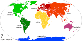
A continent is any of several large geographicalregions. Continents are generally identified by convention rather than any strict criteria. A continent could be a single landmass or a part of a very large landmass, as in the case of Asia or Europe. Due to this, the number of continents varies; up to seven or as few as four geographical regions are commonly regarded as continents. Most English-speaking countries recognize seven regions as continents. In order from largest to smallest in area, these seven regions are Asia, Africa, North America, South America, Antarctica, Europe, and Australia. Different variations with fewer continents merge some of these regions; examples of this are merging North America and South America into America, Asia and Europe into Eurasia, and Africa, Asia, and Europe into Afro-Eurasia. (Full article...)
Image 5
Superstructure of the Kola Superdeep Borehole, 2007
The Carnian pluvial episode (CPE), often called the Carnian pluvial event, was an interval of major change in global climate that was synchronous with significant changes in Earth's biota both in the sea and on land. It occurred during the latter part of the Carnian Stage, a subdivision of the late Triassic period, and lasted for perhaps 1–2 million years (around 234–232 million years ago). (Full article...)
The Mariana Trench is an oceanic trench located in the western Pacific Ocean, about 200 kilometres (124mi) east of the Mariana Islands; it is the deepest oceanic trench on Earth. It is crescent-shaped and measures about 2,550km (1,580mi) in length and 69km (43mi) in width. The maximum known depth is 10,984±25 metres (36,037±82ft; 6,006±14 fathoms; 6.825±0.016mi) at the southern end of a small slot-shaped valley in its floor known as the Challenger Deep. The deepest point of the trench is more than 2km (1.2mi) farther from sea level than the peak of Mount Everest. (Full article...)
The Lambert azimuthal equal-area projection is a projection used for mapping a sphere to a disk. It accurately represents area in all regions of the sphere, but it does not accurately represent angles. It is used in scientific disciplines such as geology for plotting the orientations of lines in three-dimensional space, and by the National Atlas of the US in its online map-making application.
Curiosity is a car-sized rover designed to explore the crater Gale on Mars as part of NASA's Mars Science Laboratory mission. It was launched from Cape Canaveral in November2011 and landed on Aeolis Palus inside Gale on August6, 2012, at 05:17UTC. Curiosity's landing site, nicknamed Bradbury Landing, was less than 2.4km (1.5mi) from the center of the rover's touchdown target after a 560-millionkm (350-millionmi) journey. The rover's goals include an investigation of the Martian climate and geology; assessment of whether the selected field site inside Gale has ever offered environmental conditions favorable for microbial life, including investigation of the role of water; as well as planetary habitability studies in preparation for human exploration.
This picture is a self-portrait of Curiosity on Mars at the "Big Sky" drilling site, where it collected a rock sample at the foothills of Aeolis Mons (Mount Sharp) in October2015. The photograph combines dozens of images taken by the Mars Hand Lens Imager (MAHLI) camera at the end of the rover's robotic arm; the arm itself is not included, although its shadow is visible on the ground. Wrist motions and turret rotations on the arm allowed MAHLI to acquire the mosaic's component images.
A geological map of Yosemite National Park (full size), showing the Cathedral Peak Granodiorite, the largest unit in the Tuolumne Intrusive Suite, which in turn is the largest granitic suite in the park. Cathedral Peak Granodiorite Rest of the Tuolumne Intrusive Suite
This false-color mosaic showing compositional variations in the geology of the Moon was constructed from a series of 53 images taken through three spectral filters by the imaging system of the Galileo spacecraft. Bright pinkish areas are highlands materials, such as those surrounding the oval lava-filled Mare Crisiumimpact basin toward the bottom. Blue to orange shades indicate volcanic lava flows. To the left of Crisium, the dark blue Mare Tranquillitatis is richer in titanium than the green and orange maria above it. Thin mineral-rich soils associated with relatively recent impacts are represented by light blue colors. The monochrome band on the right edge shows the unretouched surface of the moon.

 Image 1


 A naturally-cut diamond crystal
 Photograph of the eruption column, May 18, 1980, taken by Austin Post


 Vital article

 Featured biography


 Superstructure of the Kola Superdeep Borehole, 2007
 Darwin, c. 1854, when he was preparing On the Origin of Species
.svg)


 Categories
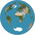 Image 1Map: Strebe, using GeocartThe Lambert azimuthal equal-area projection is a projection used for mapping a sphere to a disk. It accurately represents area in all regions of the sphere, but it does not accurately represent angles. It is used in scientific disciplines such as geology for plotting the orientations of lines in three-dimensional space, and by the National Atlas of the US in its online map-making application.
 Image 2Curiosity is a car-sized rover designed to explore the crater Gale on Mars as part of NASA's Mars Science Laboratory mission. It was launched from Cape Canaveral in November 2011 and landed on Aeolis Palus inside Gale on August 6, 2012, at 05:17 UTC. Curiosity's landing site, nicknamed Bradbury Landing, was less than 2.4 km (1.5 mi) from the center of the rover's touchdown target after a 560-million km (350-million mi) journey. The rover's goals include an investigation of the Martian climate and geology; assessment of whether the selected field site inside Gale has ever offered environmental conditions favorable for microbial life, including investigation of the role of water; as well as planetary habitability studies in preparation for human exploration.
 Image 3Map: Grandiose, based on a map by the United States Geological SurveyA geological map of Yosemite National Park (full size), showing the Cathedral Peak Granodiorite, the largest unit in the Tuolumne Intrusive Suite, which in turn is the largest granitic suite in the park.
 Image 4Cartographic relief depiction showing the varying age of bedrock underlying North America. This image combines a geologic map and a shaded relief image. This combination reveals the geologic history of North America through the interrelation of rock type, topography and time. Regional surface processes as well as continent-scale tectonic events are exposed in the three dimensions of space and the fourth dimension, geologic time. From most recent to oldest, age is indicated by color: yellow, green, blue, red.
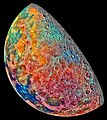 Image 5Image credit: Galileo spacecraftThis false-color mosaic showing compositional variations in the geology of the Moon was constructed from a series of 53 images taken through three spectral filters by the imaging system of the Galileo spacecraft. Bright pinkish areas are highlands materials, such as those surrounding the oval lava-filled Mare Crisium impact basin toward the bottom. Blue to orange shades indicate volcanic lava flows. To the left of Crisium, the dark blue Mare Tranquillitatis is richer in titanium than the green and orange maria above it. Thin mineral-rich soils associated with relatively recent impacts are represented by light blue colors. The monochrome band on the right edge shows the unretouched surface of the moon.


 Commons
 Wikibooks
 Wikidata
 Wikinews
 Wikiquote
 Wikisource
 Wikiversity
 Wikivoyage
 Wiktionary


