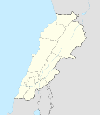
Kfar Abida, (sometimes spelled Kfar Aabida or Kfaraabida) is a village located 2 kilometres (1.2 mi) south of Batroun in the Batroun District of the North Governorate in Lebanon.[4]
Kfarabida
Kfar Aabida كفرعبيدا | |
|---|---|
Town | |
| Country | |
| Governorate | North Governorate |
| District | Batroun District |
| Elevation | 700 ft (200 m) |
| Population (2007) | |
| • Total | 9,613 |
| Alternative name | Fadaous Sud |
|---|---|
| Location | 2 kilometres (1.2 mi) south of Batroun, Lebanon |
| Region | North Governorate |
| Coordinates | 34.226389°N 35.66°E |
| Type | Flint factory[1] |
| Part of | Tell Fadous |
| Length | 800 meters[2] |
| History | |
| Cultures | Qaraoun |
| Site notes | |
| Archaeologists | Maurice Tallon, Dörte Rokitta-Krumnow[3] |
| Public access | Yes |
History
Neolithic
Located south of the tell, is Fadous Sud, a Heavy Neolithic site of the Qaraoun culture.[5][6]

Bronze Age (Tell Fadous)
Early Bronze
On the coast, in the southwest of the town, lies an archaeological tell, Tell Fadous. The site may have been part of Byblos (12 km) to the south. Ceramic and architectural similaritiies are found from Sidon in the south to Tell Arqa in the north.
Phase III (EB II) shows a regular layout of the settlement with buildings separated by narrow streets.[7]
Phase IV (EB III) has a different layout where the buildings are spaced farther apart.[8]
References
External links
Wikiwand in your browser!
Seamless Wikipedia browsing. On steroids.
Every time you click a link to Wikipedia, Wiktionary or Wikiquote in your browser's search results, it will show the modern Wikiwand interface.
Wikiwand extension is a five stars, simple, with minimum permission required to keep your browsing private, safe and transparent.
