Loading AI tools
The Centre is a public open space, transport interchange and cultural destination in the central area of Bristol, England, created by a gradual process of bridging and culverting over the diverted course of the River Frome.[1] The northern end of The Centre, known as Magpie Park, is skirted on its western edge by Colston Avenue; the southern end, the Centre Promenade, is a larger paved area bounded by St Augustine's Parade to the west, Broad Quay the east, and St Augustine's Reach (part of the Floating Harbour) to the south,[2].
The Centre has been altered on a number of occasions, initially to ease traffic flow[3][4] but latterly to try to strike a balance between its use as both a public open space and an important traffic corridor.[5] The most recent alterations to accommodate the MetroBus bus rapid transit scheme were completed in 2017.[6]
The infilling of the northern part of St Augustine's Reach allowed for the creation of a paved triangular tram terminus. Various names were suggested for this, including St Augustine's Open Space, the Drawbridge, Colston's Cross or City Gardens, but the Bristol Tramways and Carriage Company spurned these and adopted the name 'Tramways Centre',[7] which became shortened to 'The Centre'.[8] Although this name does not appear on conventional street maps it is widely understood locally,[9] and is used to refer to the open space in official documents such as the College Green Conservation Area Character Assessment.[10]
The Centre owes its form to a channel dug in the 1240s which diverted the River Frome to provide additional quays and wharves for the burgeoning Bristol Docks.[11] This channel, St Augustine's Reach, became the heart of the docks, but as these were expanded with the building of the Floating Harbour and Avonmouth Docks, the Drawbridge which crossed the Reach at the end of Clare Street and through which vessels passed to access the wharves at its northern end began to be seen as a source of "great congestion" to traffic.[12] This may be an understatement; it was often left open for twenty minutes while ships were roped up.[13]
Colston Avenue and 'Magpie Park'
In 1892 The Drawbridge was replaced by St Augustine's Bridge;[14] at the same time the docks to the north were infilled and the River Frome was arched over.[15] Under the Back, the road on the west side of this stretch of St Augustine's Reach, and Narrow Quay on the east side were replaced by a new road named Colston Avenue;[16] this encircled an open space which became known as named Magpie Park, after the newspaper The Bristol Magpie whose offices were located on the western side of Colston Avenue near Zed Alley.[17] The Bristol Industrial and Fine Arts Exhibition was held here in 1893; this was a popular attraction which saw 500,000 attendees and raised £2200 for charity.[18] A drinking fountain near Colston's statue commemorates this exhibition.[19] Since 1932 this area has been the site of the Bristol Cenotaph,[20] the focus of local remembrance.[21]
Tramways Centre
During the 1890s, Bristol's tramway system was expanded and electrified. In 1896 the Bristol Tramways and Carriage Company moved their head office to premises at 1–3 St Augustine's Parade, where they remained until 1970.[22] The need for a central interchange was recognised and to this end a large triangular traffic island, later nicknamed 'Skivvy's Island' because of its use by domestic servants,[23] was built between the BT&CC offices and St Augustine's Bridge.[24] The Tramways Centre became the most important of the BT&CC's three central termini, serving more routes than the others at Bristol Bridge and Old Market.[25] It was the terminus for trams from the north and east of the city, and trams from Hotwells to Temple Meads station and Brislington also stopped here. Passengers could straightforwardly alight from one tram and board another to continue their journey without the need to cross roads. A large three-faced ornamental clock was fixed high on the Tramways offices, and 'under the clock on The Centre' became a popular meeting place.[26][27]
J. B. Priestley visited Bristol in 1933, and described The Centre as 'a place where trams and coastal steamers seemed in danger of collision'.[28]
Buses first started to use the Tramways Centre in 1910,[29] initially only on the route to Clifton.[25] By 1913, ten bus routes started from The Centre.[30] In 1938 and 1939 the tram routes serving the Tramways Centre were replaced by buses,[31] so that trams ceased to use the island. Trams elsewhere in the city ceased completely in 1941.[32]
Inner Circuit Road
In 1936 construction started on a culvert covering the area between St Augustine's Bridge and the southern end of Broad Quay.[33] This created a route for the Inner Circuit Road, which had already bisected Queen Square, to continue northwards. Construction continued despite the outbreak of war. A large elongated roundabout was formed, with the central space initially being used as a car park.[34] The Tramways Centre island remained, devoid of trams.[3]
After the war the central space was planted with municipal lawns and ornamental flower beds and became known as the Centre Gardens.[35] Intrusive traffic, however, made it an obstacle to cross rather than a place to linger.[36]
1957 remodelling
The Inner Circuit Road was extended northwards into Colston Avenue in 1957–58. The Tramways Centre island was removed and the Centre Gardens island was extended to a point near the end of St Stephen's Street where a new road was cut across, reducing the length of Magpie Park and requiring the removal of a number of mature plane trees.[37]
1998 remodelling
It had been recognised since the 1960s that the southern half of the Inner Circuit Road had badly impacted the amenity of Queen Square and The Centre,[38] and by the 1990s tentative steps were being taken towards downgrading this part of the road and transferring traffic along less sensitive routes. By the mid-1990s, the road across Queen Square had been closed and plans were being developed to re-balance The Centre in favour of pedestrians and public transport. Bristol City Council launched a consultation exercise in 1996, in which the public were asked to choose between a 'Dock Option' (reopening the old harbour as far as St Augustine's Bridge) and a cheaper 'Promenade Option'. Both options involved closing the road across Quay Head; the Promenade Option used the new space to create a larger pedestrianised area in place of the Centre Gardens, with fountains, a cascade leading down to the waterside, and a sail structure to evoke Bristol's maritime past. The remaining road space in both options would be designed to give greater priority to public transport.[5]
Despite a strong local desire to reinstate the open waters of the River Frome,[9] the Council decided to build the 'Promenade Option'. This soon came under criticism for its poor safety, particularly after a number of pedestrians were injured by vehicles and at least two people struck by buses and killed.[39] The new design was also criticised for its traffic noise and fumes, "dribbling" fountains, poor traffic flow, poor cycling infrastructure, and delays to public transport.[40] Few were happy with the new design, and many were disappointed that the 'Dock Option' had not been pursued.[40]
The area around the pedestrian crossing at the Baldwin Street end of Broad Quay was altered in 2003 after the Bristol Coroner called for improvements.[41]
Despite remedial work in 2007, the sail structure was found to be unsafe and removed in 2009.[42]
2015 remodelling for MetroBus
Between 2015 and 2018 the layout of The Centre was changed once more, this time to accommodate the MetroBus bus rapid transit scheme.
Private motor traffic was routed along the western edge of The Centre, and the gyratory traffic system was replaced by extended and more accessible pedestrian spaces. The new layout reduced the number of routes available to general traffic, some of which was diverted away from the area, whilst improving segregation for cycles and buses.[6] The taxi ranks were relocated, new bus stops were constructed for MetroBus services, and Baldwin Street was extended across the Centre Promenade.[43]
Early indications suggest that journey times have been improved by these changes.[44]
As well as the Cenotaph, Magpie Park has statues of MP Edmund Burke (1894)[45] and slave trader Edward Colston (1895, by John Cassidy).[46] St Mary on the Quay stands on Colston Avenue to the west of the park, and St Stephen's Church stands nearby to the east.
The southern end of The Centre (the Centre Promenade) has a 1723 lead statue of Neptune, moved to The Centre from Temple Street in 1949 and now Grade II* listed.[47][48] There is a modern water feature with fountains, and another stepped water feature leads down to a ferry landing stage at the current head of St Augustine's Reach. There is a busy taxi rank on Colston Avenue, near its junction with Baldwin Street.
On Broad Quay, the former head office tower of the Bristol and West Building Society has recently been refurbished as a hotel[49] and serviced flats.[50]
The Centre is not the historic centre of Bristol; the heart of the Saxon town lies at the crossroads of High Street, Wine Street, Corn Street and Broad Street.[51] Neither is it a major shopping area; the central shopping district is centred on Broadmead.[52] It is, however, an important local transport interchange and cultural destination.[53] Many local bus services terminate at or pass through here,[54] and it is also served by ferry services to Hotwells and Bristol Temple Meads station,[55] and has busy taxi ranks.[56]
Three of Bristol's major entertainment venues lie within a short distance of The Centre: The Hippodrome, still displaying nautical motifs reflecting the time when it faced onto the open waters of St Augustine's Reach, stands to the west of the Centre Promenade on St Augustine's Parade; the former Colston Hall, currently being refurbished,[57] is a few metres away on Colston Street, and the Theatre Royal is on nearby King Street.
The Centre is part of the College Green Conservation Area.[58]
These listed buildings are located in The Centre:
| Number | Grade | Year listed | Description |
|---|---|---|---|
| Statue of Edmund Burke, Broad Quay | II | 1977 | Statue of Edmund Burke[45] |
| Statue of Edward Colston, Colston Avenue | II | 1977 | Statue of Edward Colston[59] |
| Drinking Fountain, Colston Avenue | II | 1977 | Drinking Fountain, Colston Avenue[19] |
| Cenotaph, Colston Avenue | II | 1977 | Cenotaph[20] |
| Cenotaph, Colston Avenue | II | 1977 | Four lamps approximately 4 metres from each corner of The Cenotaph[60] |
| West Gate, Colston Avenue | II | 1981 | West Gate[61] |
| 11 Small Street | II | 1975 | 11, Small Street[62] |
| Quay Head House, Colston Avenue | II | 1977 | Quay Head House[63] |
| 1, 3 and 5 St Stephens Street | II | 1994 | 1, 3 and 5, St Stephens Street[64] |
| 1, 2 and 3 Broad Quay | II | 1974 | 1, 2 and 3, Broad Quay[65] |
| 4 Broad Quay | II | 1974 | 4, Broad Quay[66] |
| 5 and 6 Broad Quay | II | 1974 | 5 and 6, Broad Quay[67] |
| 7 Broad Quay | II | 1974 | 7, Broad Quay[68] |
| Neptune statue, St Augustine's Quay | II* | 1959 | Neptune statue[47] |
| Attached wall, piers and gates to north of Transit Shed E | II | 1977 | Attached wall, piers and gates to north of Transit Shed E[69] |
 St Augustine's Reach, pre-1850, looking south across what is now Magpie Park
 The Drawbridge, looking towards Clare Street and Baldwin Street
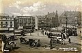 The Tramways Centre in the early 1900s
 The Centre, 1958
 Similar view of The Centre, 2005
 The water fountains and paddling area in 2006, part of the 'Promenade Option'. The sail structure, removed in 2009, is shown behind
 Magpie Park, before 2015 remodelling
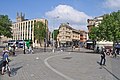 Looking across newly-extended Baldwin Street into Clare Street, 2018
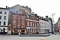 Magpie Park and St Stephen's St, 2018
 St Mary on the Quay Church
,_BRO_Picbox-7-PBA-22,_1250x1250.jpg)
.jpg)


Wikiwand in your browser!
Seamless Wikipedia browsing. On steroids.
Every time you click a link to Wikipedia, Wiktionary or Wikiquote in your browser's search results, it will show the modern Wikiwand interface.
Wikiwand extension is a five stars, simple, with minimum permission required to keep your browsing private, safe and transparent.