Wendeng, Weihai
District in Shandong, People's Republic of China From Wikipedia, the free encyclopedia
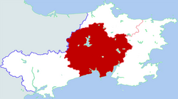
Wendeng District (Chinese: 文登区; pinyin: Wéndēng Qū) is a district of Weihai, Shandong province, China. Wendeng is primarily an industrial based area, with a large minority of citizens working as farmers. Wendeng was originally a county, then converted to a county-level city in 1988[citation needed], then converted to an urban district in March 2014.[3]
Wendeng
文登区 Wenteng | |
|---|---|
 Location in Weihai | |
| Coordinates: 37°11′38″N 122°03′29″E | |
| Country | People's Republic of China |
| Province | Shandong |
| Prefecture-level city | Weihai |
| Area | |
| • Total | 1,616 km2 (624 sq mi) |
| Population (2019)[2] | |
| • Total | 593,100 |
| • Density | 370/km2 (950/sq mi) |
| Time zone | UTC+8 (China Standard) |
| Postal code | 264400 |
| Website | www |
Administrative divisions
As 2017, this district is divided to 3 subdistricts, 12 towns and 1 other.[4]
- Subdistricts
- Longshanlu Subdistrict (龙山路街道)
- Tianfulu Subdistrict (天福路街道)
- Huanshanlu Subdistrict (环山路街道)
- Towns
|
- Others
- Wendeng Development Zone (文登开发区)
Climate
| Climate data for Wendeng (1991–2020 normals, extremes 1981–2010) | |||||||||||||
|---|---|---|---|---|---|---|---|---|---|---|---|---|---|
| Month | Jan | Feb | Mar | Apr | May | Jun | Jul | Aug | Sep | Oct | Nov | Dec | Year |
| Record high °C (°F) | 12.8 (55.0) |
19.0 (66.2) |
22.8 (73.0) |
29.0 (84.2) |
33.6 (92.5) |
35.6 (96.1) |
35.7 (96.3) |
35.9 (96.6) |
33.5 (92.3) |
30.0 (86.0) |
23.5 (74.3) |
17.6 (63.7) |
35.9 (96.6) |
| Mean daily maximum °C (°F) | 2.4 (36.3) |
4.8 (40.6) |
10.0 (50.0) |
16.6 (61.9) |
22.6 (72.7) |
26.4 (79.5) |
28.7 (83.7) |
29.0 (84.2) |
25.8 (78.4) |
19.8 (67.6) |
12.1 (53.8) |
5.0 (41.0) |
16.9 (62.5) |
| Daily mean °C (°F) | −1.8 (28.8) |
0.1 (32.2) |
4.8 (40.6) |
11.2 (52.2) |
17.2 (63.0) |
21.6 (70.9) |
24.8 (76.6) |
25.0 (77.0) |
20.9 (69.6) |
14.6 (58.3) |
7.5 (45.5) |
0.8 (33.4) |
12.2 (54.0) |
| Mean daily minimum °C (°F) | −5.1 (22.8) |
−3.5 (25.7) |
0.9 (33.6) |
6.9 (44.4) |
12.7 (54.9) |
17.9 (64.2) |
21.9 (71.4) |
21.8 (71.2) |
16.8 (62.2) |
10.2 (50.4) |
3.7 (38.7) |
−2.5 (27.5) |
8.5 (47.3) |
| Record low °C (°F) | −18.2 (−0.8) |
−17.8 (0.0) |
−9.5 (14.9) |
−5.9 (21.4) |
1.0 (33.8) |
7.7 (45.9) |
14.8 (58.6) |
12.1 (53.8) |
5.3 (41.5) |
−2.0 (28.4) |
−10.6 (12.9) |
−19.0 (−2.2) |
−19.0 (−2.2) |
| Average precipitation mm (inches) | 14.4 (0.57) |
15.6 (0.61) |
19.7 (0.78) |
43.5 (1.71) |
61.9 (2.44) |
82.8 (3.26) |
181.5 (7.15) |
189.2 (7.45) |
70.9 (2.79) |
28.4 (1.12) |
35.7 (1.41) |
27.2 (1.07) |
770.8 (30.36) |
| Average precipitation days (≥ 0.1 mm) | 6.6 | 4.8 | 4.3 | 5.8 | 7.9 | 8.2 | 12.3 | 11.0 | 7.4 | 5.9 | 6.7 | 8.6 | 89.5 |
| Average snowy days | 8.1 | 4.7 | 1.8 | 0.2 | 0 | 0 | 0 | 0 | 0 | 0.2 | 2.7 | 8.9 | 26.6 |
| Average relative humidity (%) | 67 | 65 | 62 | 61 | 65 | 75 | 83 | 83 | 74 | 69 | 69 | 68 | 70 |
| Mean monthly sunshine hours | 161.3 | 174.7 | 221.5 | 233.1 | 250.3 | 212.2 | 164.6 | 189.1 | 209.2 | 208.2 | 162.4 | 149.5 | 2,336.1 |
| Percent possible sunshine | 52 | 57 | 59 | 59 | 57 | 48 | 37 | 45 | 57 | 61 | 54 | 50 | 53 |
| Source: China Meteorological Administration[5][6] | |||||||||||||
Transport
- Weihai Dashuipo Airport
- China National Highway 309
- Yanji Expressway
- Qingwei Expressway
- Shandong Provincial Highway 204
- Shandong Provincial Highway 804
- Shandong Provincial Highway 901
Friendship Cities
 Cheonan-si, South Chungcheong, South Korea
References
External links
Wikiwand in your browser!
Seamless Wikipedia browsing. On steroids.
Every time you click a link to Wikipedia, Wiktionary or Wikiquote in your browser's search results, it will show the modern Wikiwand interface.
Wikiwand extension is a five stars, simple, with minimum permission required to keep your browsing private, safe and transparent.

