Top Qs
Timeline
Chat
Perspective
Điện Biên province
Province of Vietnam From Wikipedia, the free encyclopedia
Remove ads
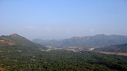
Điện Biên is a province in the Northwest region of Vietnam. It is bordered by Lai Châu to the northeast, Sơn La to the southeast, Pu'er City, Yunnan, China, to the northwest, and Phongsaly province in Laos to the west. The province covers an area of about 9,540 km2 (3,683 sq mi) and as of 2024 it had a population of 656,700 people.[7]
You can help expand this article with text translated from the corresponding article in Vietnamese. (March 2013) Click [show] for important translation instructions.
|
Remove ads
History
The name "Điện Biên" (chữ Hán: 奠邊) means "stable frontier" (referring to Điện Biên's location on the border between Lan Xang and Vietnam).[8] Điện Biên has various ancient monuments including the caves Thẩm Khương, as well as Thẩn Búa in Tuần Giáo. The original settlers were the Ai Lao or Tai people who are a direct ancestor of Lao people in Laos today. The names of some villages and towns still use words of Tai origin, such as Mường (city) and Tham (cave).
In the 9th and 10th centuries, the Lự in Mường Thanh were the most developed in the area and controlled Sìn Hồ, Mường Lay, and Tuần Giáo.
In the 11th and 12th centuries, Tai people (not to be confused with the Thai people of Thailand) from Mường Ôm and Mường Ai occupied Mường Lò in Nghĩa Lộ and Mường Thanh in Điện Biên. They eventually gained control of the whole area between Mường Lò and Mường Thanh (Điện Biên).
Remove ads
Places
Chua ta cave: Located at an altitude of nearly 1,000m above sea level, in a limestone mountain range with a geological tectonic process of millions of years, Tham Khen cave in Muong Dun commune, Tua Chua district has also been recognized by the Ministry of Culture. Sports and Tourism ranked national relics and scenic spots according to decision No. 3086/QD-BVHTTDL dated October 27, 2020. In addition to being unique like other caves, Chua Ta cave also has two typical types of ecosystems: Limestone mountain ecosystem and cave ecosystem. This place converges the diverse properties of nature.[9]
Remove ads
Climate
Summarize
Perspective
Điện Biên province has a humid subtropical climate (Köppen Cwa).
Remove ads
Administrative divisions
Điện Biên is subdivided into 10 district-level sub-divisions:
They are further subdivided into five commune-level towns (or townlets), 116 rural communes, and nine wards.
Remove ads
Tourism
Điện Biên has great tourism potential, especially in cultural and historical attractions. Key sites include the Điện Biên Phủ Campaign headquarters in Mường Phăng, French strongholds like Him Lam and Độc Lập, hills A1, C1, E1, and the De Castries bunker. Bản Phủ Citadel and the temple of Hoàng Công Chất are also popular.[12]
Notable monuments include the Điện Biên Phủ Victory Monument (inaugurated in 2004) and the Victory Museum (opened in 2014). The province also offers natural attractions like Mường Nhé primeval forest, caves (Pa Thơm, Thẩm Púa), hot springs (Hua Pe, U Va), and lakes (Pá Khoang, Pe Luông).[13] In the first half of 2018, Điện Biên welcomed around 490,000 tourists, including 94,000 international visitors, generating nearly 644 billion VND in revenue.[14]
Remove ads
Places in Điện Biên
References
External links
Wikiwand - on
Seamless Wikipedia browsing. On steroids.
Remove ads


