Top Qs
Timeline
Chat
Perspective
53 Stations of the Tōkaidō
From Wikipedia, the free encyclopedia

Remove ads
The 53 Stations of the Tōkaidō (東海道五十三次, Tōkaidō Gojūsan-tsugi) are the rest areas along the Tōkaidō, which was a coastal route that ran from Nihonbashi in Edo (modern-day Tokyo) to Sanjō Ōhashi in Kyoto.[1] There were originally 53 government post stations along the Tōkaidō, where travelers had to present traveling permits at each station if wanting to cross.
In 1619, the Ōsaka Kaidō (大阪街道) was developed to extend the Tōkaidō so that it would reach Kōraibashi in modern-day Osaka. Instead of going to Sanjō Ōhashi, travelers would leave from Ōtsu-juku and travel towards Fushimi-juku. Because of the addition of these four post towns, the Tōkaidō is occasionally referred to as having 57 stations. Another name for this extension was Kyōkaidō (京街道).
The inland Nakasendō also started at Nihonbashi, and converged with the Tōkaidō at Kusatsu-juku. Shio no Michi intersected with the Tōkaidō at Okazaki-shuku.
Remove ads
Stations of the Tōkaidō
 Nihonbashi's highway distance marker, from which modern highway distances are measured
 Odawara-juku in the 1830s, as depicted by Hiroshige in The Fifty-three Stations of the Tōkaidō
 The countryside around Yui-shuku in the 1830s
 Kanaya-juku bordering the Ōi River in the 1830s
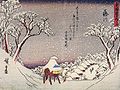 Fujikawa-shuku in the 1830s
 Ishiyakushi-juku in the 1830s
 Seki-juku in the 1830s
 A boat going down the Yodo River towards Kōraibashi


Remove ads
See also
Notes
References
External links
Wikiwand - on
Seamless Wikipedia browsing. On steroids.
Remove ads