Top Qs
Timeline
Chat
Perspective
Asago, Hyōgo
City in Kansai, Japan From Wikipedia, the free encyclopedia

Remove ads
Asago (朝来市, Asago-shi) is a city located in northern Hyōgo Prefecture, Japan. As of 31 March 2022[update], the city had an estimated population of 28,971 in 12245 households and a population density of 72 persons per km2.[1] The total area of the city is 403.06 square kilometres (155.62 sq mi).


Remove ads
Geography
Summarize
Perspective
Asago is located in the north of Hyōgo Prefecture. It is located in the east of Chūgoku Mountains, and the mountains and forests were occupy 93% of the town.[2] The Maruyama flows from south to north in the town.[3] The Tataragi Dam was built across the Tataragi stream, a tributary of the Maruyama.[4]
Neighbouring municipalities
Hyōgo Prefecture
Kyoto Prefecture
Climate
Asago has a humid subtropical climate (Köppen climate classification Cfa) with hot summers and cool to cold winters. Precipitation is significantly higher in summer than in winter, though on the whole lower than most parts of Honshū, and there is no significant snowfall. The average annual temperature in Asago is 13.4 °C (56.1 °F). The average annual rainfall is 2,091.8 mm (82.35 in) with July as the wettest month. The temperatures are highest on average in August, at around 25.7 °C (78.3 °F), and lowest in January, at around 1.9 °C (35.4 °F).[5] The highest temperature ever recorded in Asago was 38.0 °C (100.4 °F) on 20 August 2020; the coldest temperature ever recorded was −12.8 °C (9.0 °F) on 28 February 1981.[6]
Remove ads
Demographics
Per Japanese census data, the population of Asago in 2020 is 28,989 people.[9] Asago has been conducting censuses since 1960.
Remove ads
History
Summarize
Perspective
The area of Asago was in ancient Tajima Province and is the location of many burial mounds from the Kofun period. These include the Chasuriyama Kofun in Wadayama, one of the largest enpun (円墳)-style elliptical burial mounds in the Kansai region. The Ikuno Silver Mine opened in 807 in the early Heian period and mining continue through the Edo Period. During the Sengoku period the area was under the control of the Yamana clan, the shugo of Tajima Province and Takeda Castle was the stronghold their retainers, the Otagaki clan. Following the establishment of the Tokugawa shogunate, the area was mostly tenryō territory under direct control of the shogunate due to the importance of the silver mine, with some small areas undertone control of Toyooka Domain or Izushi Domain. Following the Meiji restoration, the area was under"Toyooka Prefecture" until incorporated into Hyōgo Prefecture in 1876. The town of Ikuno and the villages of Yamaguchi and Akagawa were created with the establishment of the modern municipalities on April 1, 1889. Asago was founded on March 31, 1954, from the merger of the former villages of Yamaguchi and Nakagawa.[3] By 2004, the town had an estimated population of 7,465 and a density of 57.33 persons per km2. The total area was 130.20 km2.[10] On April 1, 2005, Asago absorbed the towns of Ikuno, Santō and Wadayama (all from Asago District) to create the city of Asago.
Government
Asago has a mayor-council form of government with a directly elected mayor and a unicameral city council of 18 members. Asago contributes one member to the Hyogo Prefectural Assembly. In terms of national politics, the city is part of Hyōgo 5th district of the lower house of the Diet of Japan.
Economy
Asago has mostly a rural economy based on agriculture and commerce. Local industries include food processing, metal products, electrical machinery, and non-ferrous metals.
Education
Asago has seven public elementary schools and four public middle schools operated by the city government and two public high schools operated by the Hyōgo Prefectural Department of Education. There is also one private middle school and one private high school. The prefecture also operates one special education school for the handicapped.
Transportation

Railway
Highways
International relations
Sister cities
 Newberg, Oregon, United States
 Perth, Ontario, Canada
Friendship cities
 Barbizon, France
Local attractions
- Asago Art Village
- Ikuno Dam
- Ikuno Ginzan Silver Mine
- Kuchiganaya area
- Tanyo Museum
- Ikuno Shoin
- Kurokawa Dam
- Takeda Castle
- Tataragi Dam
 Scenery of Kuchiganaya, Ikuno
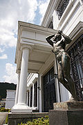 Tanyo Museum
 Tataragi Dam
 Asago Art Village


Noted people from Asago
- Takashi Shimura, actor
- Sanzo Wada, artist, costume designer
References
External links
Wikiwand - on
Seamless Wikipedia browsing. On steroids.
Remove ads