Bègles

Commune in Nouvelle-Aquitaine, France From Wikipedia, the free encyclopedia

Bègles

Bègles (French: [bɛɡl]; Gascon: Begla) is a commune in the Gironde department in southwestern France.

Quick Facts Country, Region ...
Bègles
Thumb
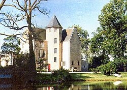
Château de Francs
Thumb
Location of Bègles
Thumb
Thumb
Bègles
Thumb
Bègles
Coordinates: 44°48′31″N 0°32′52″W
CountryFrance
RegionNouvelle-Aquitaine
DepartmentGironde
ArrondissementBordeaux
CantonTalence and Villenave-d'Ornon
IntercommunalityBordeaux Métropole
Government
  Mayor (2020–2026) Clement Rossignol-Puech[1]
Area
1
9.96 km2 (3.85 sq mi)
Population
 (2022)[2]
30,968
  Density3,100/km2 (8,100/sq mi)
Time zoneUTC+01:00 (CET)
  Summer (DST)UTC+02:00 (CEST)
INSEE/Postal code
33039 /33130
Elevation3–18 m (9.8–59.1 ft)
(avg. 8 m or 26 ft)
1 French Land Register data, which excludes lakes, ponds, glaciers > 1 km2 (0.386 sq mi or 247 acres) and river estuaries.
Close

It is a suburb of the city of Bordeaux and is adjacent to it on the south. Bègles station has rail connections to Langon and Bordeaux.

Population

More information Year, Pop. ...
Historical population
YearPop.±% p.a.
1793 2,115    
1800 1,526−4.56%
1806 1,903+3.75%
1821 2,050+0.50%
1831 2,322+1.25%
1836 2,518+1.63%
1841 2,592+0.58%
1846 2,745+1.15%
1851 2,844+0.71%
1856 3,286+2.93%
1861 4,005+4.04%
1866 4,764+3.53%
1872 5,547+2.57%
1876 6,202+2.83%
1881 7,238+3.14%
1886 8,919+4.27%
1891 10,535+3.39%
1896 10,372−0.31%
YearPop.±% p.a.
1901 12,104+3.14%
1906 12,588+0.79%
1911 14,055+2.23%
1921 16,590+1.67%
1926 18,349+2.04%
1931 21,582+3.30%
1936 20,989−0.56%
1946 22,590+0.74%
1954 23,176+0.32%
1962 24,388+0.64%
1968 27,330+1.92%
1975 25,680−0.89%
1982 23,318−1.37%
1990 22,604−0.39%
1999 22,475−0.06%
2007 24,914+1.30%
2012 25,380+0.37%
2017 28,601+2.42%
Source: EHESS[3] and INSEE (1968–2017)[4]
Close

Personalities

Bègles was the birthplace of:

International relations

Bègles is twinned with:

See also

References

Loading related searches...

Wikiwand - on

Seamless Wikipedia browsing. On steroids.