Top Qs
Timeline
Chat
Perspective
Batura Muztagh
From Wikipedia, the free encyclopedia
Remove ads
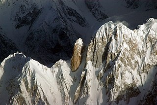
The Batura Muztagh (Urdu: بتورا موز تاغ) mountains are a sub-range of the Karakoram mountain range. They are located in Passu (Gojal Valley) in the Hunza District of Gilgit-Baltistan region in northern Pakistan.[1]
They are the westernmost sub-range of the Karakoram, running from Chalt village in Bar Valley in the east to Kampir Dior in the Kurumbar Valley in the west, and they separate the Hindu Raj range from the Karakoram range. The Muchu Chhish peak located in this sub-range remained for many years the second highest unclimbed peak in the world, until its successful summit in 2024 by a Czech team.[2][3][4]
Remove ads
Selected peaks in the Batura Muztagh

Remove ads
Books, pamphlets, and maps
- Neate, Jill (1989). High Asia: An Illustrated History of the 7000 Metre Peaks. Seattle: The Mountaineers. ISBN 0-89886-238-8.
- Batura Mustagh (sketch map and pamphlet) by Jerzy Wala, 1988.
- Orographical Sketch Map of the Karakoram by Jerzy Wala, 1990. Published by the Swiss Foundation for Alpine Research.
See also
Notes
- This data is from the Himalayan Index and is not always correct. In particular it is not clear if Batura Sar has really had four ascents or only three.
- Sometimes called Batura I.
- Sometimes called Ultar II or Bojohagur Duanasir II.
- Also known as Sang-e-Marmar (or Sangemarmar), and sometimes referred to by locals as Marble Peak.
- The heights given for this peak vary between 6949m and 7050m.
- This elevation is approximate.
Remove ads
References
External links
Wikiwand - on
Seamless Wikipedia browsing. On steroids.
Remove ads


