Top Qs
Timeline
Chat
Perspective
Boumerdès Valley
Valley in Boumerdès, Algeria From Wikipedia, the free encyclopedia

Remove ads
Boumerdes Valley is a watercourse that originates in the Khachna Mountains and flows through the Kabylia region, passing through Boumerdès Province and into the Mediterranean Sea near the city of Boumerdès.[1]


Remove ads
Watercourse
Boumerdes Valley is characterized by a riverbed free from schist and clay materials.[2] This feature, which it shares with other rivers such as Arbia Valley, Meraldene River, Boudouaou Valley, and Isser River, facilitates the extraction of sand and gravel for use in mortar and concrete production.[3][4]
The riverbed of Boumerdès Valley serves as a natural corridor, with a width ranging from 5 to 600 meters. It descends gradually from its confluence with Meraldene River and Arbia Valley in the municipality of Thénia Beni Aicha, near Mount Bouarous in the south, flowing towards its mouth in the Mediterranean Sea to the east of Boumerdès city.[5]
This moderate slope enabled the construction of the Thenia Beni Aicha Dam in 1913.[6] During the rainy season, water flow increases, prompting the construction of bridges and pathways to facilitate the movement of residents in the villages and neighborhoods along its banks.[7]
Remove ads
The path
Boumerdes Valley flows through a single coastal province in Algeria, traversing the Khachna Mountains.[8]
Remove ads
Valleys
Boumerdes Valley intersects with several other streams and rivers along its course within Boumerdès Province.[13]
Dams

Boumerdès Valley passes through several dams along its course in Boumerdès Province.[18]

National roads
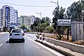
Boumerdès Valley intersects with several national roads along its course.[21]
Gallery
 The mouth of the Boumerdès Valley, east of Boumerdès city
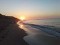 The mouth of the Boumerdès Valley, east of Boumerdès city
 The mouth of the Boumerdès Valley, east of Boumerdès city


See also
References
Wikiwand - on
Seamless Wikipedia browsing. On steroids.
Remove ads