Top Qs
Timeline
Chat
Perspective
Bulgaria–Romania border
International border From Wikipedia, the free encyclopedia

Remove ads
The Bulgaria–Romania border (Bulgarian: Граница между България и Румъния, romanized: Granitsa mezhdu Bŭlgariya i Rumŭniya, Romanian: Frontiera între Bulgaria și România) is the state border between Bulgaria and Romania.
For most of its length, the border follows the course of the lower Danube, up until the town of Silistra. From Silistra, the river continues north into the Romanian territory. East of that point, the land border passes through the historical region of Dobruja, dividing it into Northern Dobruja in Romania and Southern Dobruja in Bulgaria. The land border was first set in Article XLVI of the Treaty of San Stefano (signed in Berlin on July 13, 1878), as "a line starting from the east of Silistra and terminating on the Black Sea, south of Mangalia."[1]: 6 It was subsequently revised in several treaties, and eventually confirmed at the Paris Peace Treaties on February 10, 1947.[1]: 7
The Bulgaria–Romania border is an internal border of the European Union since 1 January 2007 when Romania and Bulgaria became EU members. Both countries are part of the Schengen Area.
Remove ads
Border crossings
- Vidin–Calafat (New Europe Bridge): road, railway
- Oryahovo-Bechet: ferry
- Nikopol-Turnu Măgurele: ferry
- Svishtov-Zimnicea: ferry
- Ruse–Giurgiu (Danube Bridge): road, railway
- Silistra–Ostrov: road
- Kaynardzha–Lipnița: road[2]
- Krushari–Dobromir: road[3]
- Kardam–Negru Vodă: road, railway
- Durankulak–Vama Veche: road
Maps
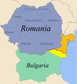 Bulgarian-Romanian border in Dobruja (in red)
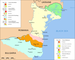 Border changes in Dobruja since 1878


See also
References
Wikiwand - on
Seamless Wikipedia browsing. On steroids.
Remove ads