Top Qs
Timeline
Chat
Perspective
Castle Frank station
Toronto subway station From Wikipedia, the free encyclopedia

Remove ads
Castle Frank is a subway station on Line 2 Bloor–Danforth of the Toronto subway. It is located at the northwest corner of Bloor Street East and Castle Frank Road.


Without any major commercial, industrial or entertainment destinations, the station primarily serves the residents of South Rosedale, from which it is within walking distance, and St. James Town and Cabbagetown by way of the 65 Parliament and 94 Wellesley bus routes. Nearby landmarks include Rosedale Heights School of the Arts and St. James Cemetery.
Remove ads
Entrances
The entrance to the station is located on the northwest corner of Castle Frank Road and Bloor Street East. The station was rated as high priority in the requirement for a second exit[2] which, although scheduled to be finished by January 2010,[3] finally opened in December 2012 after many delays.[4] This project still did not make the station accessible, although the stairs give subway riders a direct connection to the bus bays. Only an exit is provided through turnstile gates, without any way to get into the station using a pass or token that is available at the secondary entrance to many other stations.
Late in the fourth quarter of 2021, construction started to install two elevators to make Castle Frank station accessible, connecting the street-level concourse to each of the east- and westbound platforms. The project was completed in October 2024.[5]
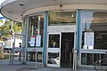 Station entrance
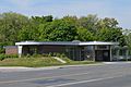 The much-delayed second exit, which opened in 2012
 Bloor–Parliament Parkette in 2013 has a bus stop beside it


Remove ads
History
Castle Frank station, opened in 1966, is named after the community that it serves. Its streets, and the brook that flows through it, are in turn named after John Graves Simcoe's summer residence in the area overlooking the Don River, which burned down in 1829.[6] The residence was named after his son Francis Simcoe. In 1954, a historical marker was placed in Prince Edward Viaduct Parkette, near the site of the historic Castle Frank residence, on the south side of Bloor Street at Castle Frank Road.
The Parliament streetcar line operated to its northerly terminus at the Viaduct Loop until 1966. No consideration was given to construct the short connection, from that location at Bloor Street East and Parliament Street across the Rosedale Ravine, which would have made the streetcar route a major feeder line to the subway station.[7] The site of the streetcar loop is now Rekai Family Parkette.[8]
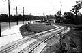 Viaduct Loop in 1926 was a terminus for streetcars
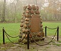 Castle Frank historical marker


Remove ads
Subway infrastructure in the vicinity

East of the station, the line runs under Bloor Street to use the lower deck of the Prince Edward Viaduct. At the end of the Viaduct, it swings to parallel Danforth Avenue on the north side. Immediately west of the station, the line crosses the Rosedale Ravine in a covered concrete bridge, then continues in a tunnel to Sherbourne station.
Surface connections
When the subway is closed, buses do not enter the station. TTC routes serving the station include:
Remove ads
References
External links
Wikiwand - on
Seamless Wikipedia browsing. On steroids.
Remove ads