Top Qs
Timeline
Chat
Perspective
Changping, Beijing
District in Beijing, People's Republic of China From Wikipedia, the free encyclopedia

Remove ads
Changping District (Chinese: 昌平区; pinyin: Chāngpíng Qū), formerly Changping County (昌平县), is a district situated in the suburbs of north and northwest Beijing. Changping has a population of 2,269,487 as of November 2020, making it the most populous suburban district of Beijing.[1]


Remove ads
History
Changping County and Jundu County which administered the area were established in the Han dynasty. Changping was incorporated into Jundu when the Northern Wei dominated; however, the condition was reversed since the Eastern Wei. The county was promoted as Changping subprefecture had jurisdiction over Miyun, Shunyi and Huairou, in the era of Zhengde during the Ming dynasty. These three counties were transferred to Shuntian Prefecture in the era of Yongzheng during the Qing dynasty. Changping became a county again after the Xinhai Revolution, and it was transferred to Beijing from Hebei in 1956.[2]
Remove ads
Geography
Summarize
Perspective
Changping District, covering an area of 1,430 square kilometres (550 sq mi), contains two subdistricts of the city of Changping and 15 towns (five of which are suburbs of Beijing) with total population of 1.83 million (2012),[3] a rapid increase from the 614,821 recorded in the 2000 census. About 34 km (21 mi) from the city center, Changping is renowned for its numerous scenic spots and tourist facilities, like Datangshan museum. It is rich in natural resources, mineral products, and rural products.
The urban area of Changping (116,961 in subdistricts) has an area of 16 km2 (6.2 sq mi) and an estimated population of 130,000. Other major urban areas are Nankou (70,000) and Yangfang (40,000).[4]
Climate
Changping District has a humid continental climate (Köppen climate classification Dwa). The average annual temperature in Changping is 13.0 °C (55.4 °F). The average annual rainfall is 517.9 mm (20.39 in) with July as the wettest month. The temperatures are highest on average in July, at around 26.8 °C (80.2 °F), and lowest in January, at around −3.0 °C (26.6 °F).
Remove ads
Administrative divisions
Summarize
Perspective
There are 8 subdistricts and 14 towns in the district.[8]
Economy
In 2017, the regional GDP of the district is 83.97 billion yuan,[10] with GDP per capita at 40.7 thousand yuan.
Features
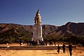
- Ming Dynasty Tombs
- Cloud Platform at Juyong Pass, one of the "three great mountain passes" of the Great Wall of China
- Triathlon Venue for the Triathlon at the 2008 Summer Olympics
- Qincheng Prison of the Ministry of Public Security (near Xiaotangshan)[11]
- Wonderland Amusement Park (Beijing)
Central government
Chinese Center for Disease Control and Prevention has its headquarters in the district.[12]
Transport
Changping District is served by four metro lines operated by Beijing Subway and one commuter line operated by Beijing Suburban Railway (BCR). Changping District is served by Beijing Subway Lines 5, 8, 13 and the Changping line.[13]
Metro
 Line 5 - Tiantongyuan North, Tiantongyuan, Tiantongyuan South
- Line 8 - Zhuxinzhuang Changping , Yuzhilu, Pingxifu, Huilongguan Dongdajie, Huoying 13
- Line 13 - Longze, Huilongguan, Huoying 8
- Changping line - Life Science Park, Zhuxinzhuang 8 , Gonghuacheng, Shahe, Shahe University Park, Nanshao, Beishaowa, Changping Dongguan, Changping, Ming Tombs, Changping Xishankou
Beijing Suburban Railway
Remove ads
Education
Colleges and universities
Primary and secondary schools
Public schools:
- Changping District No. 1 High School (北京市昌平区第一中学)
- Changping District No. 2 High School (北京市昌平区第二中学)
Private schools:
- Beijing Huijia Private School is in Changping District.[16]
- Beijing Royal School
- The Korean International School in Beijing was previously located in Changping District.[17]
Remove ads
Gallery
 Shisanling Reservoir
 Jiutai Road (九台路) in northern Changping District
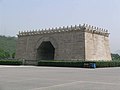


See also
References
External links
Wikiwand - on
Seamless Wikipedia browsing. On steroids.
Remove ads