Top Qs
Timeline
Chat
Perspective
East–West Corridor
Metropolitan Area in Trinidad and Tobago From Wikipedia, the free encyclopedia

Remove ads
The East–West Corridor is the built-up area of north Trinidad stretching from the capital, Port of Spain, 24 kilometres (15 mi) east to Arima. The term was coined by economist and political philosopher Lloyd Best, after gleaning the works of a technocrat named Lynette Attwell. The Corridor includes such towns as Laventille, Morvant, Barataria, San Juan, St. Joseph, Champs Fleurs, Curepe, St. Augustine, Valsayn, Tunapuna, Macoya, Trincity, Tacarigua, Arouca, D'Abadie, and El Dorado. For the most part it runs along the Eastern Main Road, between the Churchill–Roosevelt Highway and the foothills of the Northern Range. It is a densely populated and fairly congested strip of development along some of the best agricultural soils in the country.
This article needs additional citations for verification. (January 2021) |

Remove ads
Gallery
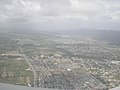 Looking west over the corridor.
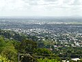 From front to back: Tunapuna, El Dorado, Tacarigua.


Remove ads
References
Wikiwand - on
Seamless Wikipedia browsing. On steroids.
Remove ads