Top Qs
Timeline
Chat
Perspective
Extreme points of Slovakia
From Wikipedia, the free encyclopedia
Remove ads
This is a list of the extreme points of Slovakia: the points that are farther north, south, east or west than any other location, as well as the highest and lowest points.
Latitude and longitude
- North: near Oravská Polhora
- South: Patince
- West: near Záhorská Ves
- East: Nová Sedlica
 Northernmost point of Slovakia
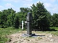 Easternmost point of Slovakia


The distance between Záhorská Ves (the westernmost point) and Nová Sedlica (the easternmost point) is 428 km.
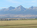
Altitude
- Maximum: Gerlachovský štít, High Tatras (2655 m)
- Minimum: Streda nad Bodrogom (94 m)
 Highest point of Slovakia
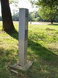 Lowest point of Slovakia


Other features
- Longest river: Vah (402,5 km).
- Deepest mountain lake: Velke Hincove pleso, High Tatras (53 m deep, 20 hectares)
- Uppermost mountain lake: Modre pleso, High Tatras (2157 m above sea level)
See also
References
Wikiwand - on
Seamless Wikipedia browsing. On steroids.
Remove ads