Top Qs
Timeline
Chat
Perspective
Gangseo District, Seoul
District of Seoul, South Korea From Wikipedia, the free encyclopedia
Remove ads
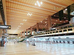
Gangseo District (Korean: 강서구; RR: Gangseo-gu; Korean pronunciation: [ka̠ŋ.sʰʌ̹.ɡu]) is one of the 25 districts (gu) of Seoul, South Korea. It is located on the south side of the Han River. South Korea's third busiest airport, Gimpo International Airport, is located in Gonghang-dong, where many flights fly to cities like Busan, Jeju, and Gwangju. The Magok Industrial Complex, located in Magok-dong, is a major hub for research and development, housing numerous R&D centers and corporate headquarters.
Remove ads
History
Summarize
Perspective
Origins
The earliest recorded name of the area was Jechapa-ui (齊次巴衣), which appears in the Samguk Sagi (History of the Three Kingdoms) under the Goguryeo section. Jecha (齊次) is derived from Jegye (齊戒), meaning ritual or sacrifice, while Pa-ui (巴衣) is an ancient word meaning “rock.” Together, the name means “rock for offering rituals.” During the Hanseong Baekje period, the Baekje king conducted rituals inside a cave at Heogabawi Rock, praying to the land gods for prosperity. This led to the name Jechapa-ui being used for the area.
Three Kingdoms Period
During the Three Kingdoms period, the Gangseo region was occupied by both Baekje and Goguryeo. It consisted of five prefectures: Geompo-hyeon (黔浦縣), Jechapa-ui-pyeonghoepa (齊次巴衣平淮把), Dongjahol (童子忽), and Suihol-hyeon (首爾忽縣).
Unified Silla Period
In 757, during the Unified Silla period, King Gyeongdeok renamed Geompo to Gimpo-hyeon (金浦縣), making it a subordinate prefecture of Jangje-gun (長堤郡).
Goryo Dynasty
In 1018, under King Hyeonjong of Goryeo, the region became part of Yanggwang-do (楊廣道) and was placed under Sujoo (樹州, present-day Bucheon). In 1391, during King Gongyang’s reign, Gyeonggi Province was divided into left and right regions, with all prefectures except Yangcheon-hyeon (陽川縣) incorporated into Gyeonggi Right Province.
Joseon Dynasty
In 1414, under King Taejong, Gimpo and Yangcheon were merged into Geumyang-hyeon (衿陽縣). However, in October of that year, the two regions were separated again, with Gimpo incorporated into Bupyeong-bu (富平府). In 1416, Gimpo regained its status as an independent prefecture. In 1632, during King Injo’s reign, Gimpo was elevated to county (gun) status.
19th-20th Centuries
By 1895, during King Gojong’s 32nd year, Korea was reorganized into 23 districts (bu), and Gimpo, Tongjin (通津), and Yangcheon became separate counties. The present-day Gangseo District was historically part of Gimpo County and the northernmost section of present-day Bucheon.
Remove ads
Geography
Location
This area is part of the Gimpo Plain, located along the banks of the Han River. The underlying bedrock consists of Precambrian granite gneiss and banded gneiss, which have been eroded over a long period, forming hilly terrain. The northern region along the Han River is a floodplain with thick sedimentary deposits, historically utilized as fertile farmland through the construction of embankments.
Several low residual hills remain in the hilly areas, including Gaehwa Mountain (131.2m), Maebong Mountain (117.7m), Ujang Mountain (93.6m), Gung Mountain (74.8m), and Kkachi Mountain (75m). These hills are surrounded by expansive gentle slopes. Additionally, the area is home to streams such as Gayangcheon and Banghwacheon, which flow northward into the Han River. Notably, Banghwacheon features an irrigation channel that takes advantage of the Han River’s reverse flow effect.
Climate
Gangseo District experiences an average annual temperature of 13.3°C, with a January average of 0.4°C and an August average of 26.5°C. The annual precipitation is approximately 1,212.3 mm.
Remove ads
Administrative divisions

- Balsan-dong (발산동 鉢山洞)
- Banghwa-dong (방화동 傍花洞)
- Gaehwa-dong (개화동 開花洞) --- called "beopjeongdong" administered by Banghwa-dong
- Deungchon-dong (등촌동 登村洞)
- Gayang-dong (가양동 加陽洞)
- Magok-dong (마곡동 麻谷洞) --- called "beopjeongdong" administered by Balsan-dong
- Gonghang-dong (공항동 空港洞)
- Gwahae-dong (과해동 果海洞) --- called "beopjeongdong" administered by Gonghang-dong
- Ogok-dong (오곡동 五谷洞) --- called "beopjeongdong" administered by Gonghang-dong
- Osoe-dong (오쇠동 五釗洞) --- called "beopjeongdong" administered by Gonghang-dong
- Hwagok-dong (화곡동 禾谷洞)
- Yeomchang-dong (염창동 鹽倉洞)
Economy
Since the Gimpo International Airport is located in gangseo district number of aviation headquarters are located nearby. The Korea Airports Corporation headquarters,[2] Korean Air's headquarters, Korean Airport Service, Ltd., and Air Total Service are located in Gonghang-dong.[3][4] Asiana Airlines's headquarters are located in Asiana Town in Osoe-dong.[5] Jin Air has its headquarters in Deungchon-dong.[6] Eastarjet has its headquarters in Banghwa 2-dong.[7]
Remove ads
Government and infrastructure
The Aviation and Railway Accident Investigation Board (ARAIB) FDR/CVR Analysis and Wreckage Laboratory is on the property of Gimpo International Airport in Gwahae-dong, Gangseo District. Previously the ARAIB had its headquarters in Gonghang-dong, Gangseo District.[8] The ARAIB headquarters are now in Sejong City.
Attractions
- Heojun Museum
- SBS Open Hall
- Gyeomjae Jeong Seon Art Museum
- LG Arts Center
- Coex Magok Lewest
- One Grove
Transportation
Railway
- Airport Railroad Co., Ltd.
- (Gyeyang District, Incheon) ← Gimpo Airport → (Goyang), (Eunpyeong District)
- Seoul Subway Line 2 Sinjeong Branch
- Banghwa — Gaehwasan — Gimpo Airport — Magok — Balsan — Ujangsan — Hwagok — Kkachisan → (Yangcheon District)
- Seoul Metro Line 9 Corporation
Remove ads
Notable people
- Lee Guk-jong (born 1969), South Korean doctor
- Kim Gun-mo (born 1968), South Korean singer-songwriter (Originally from Busan, but raised in Gangseo-gu)
- Gong Hyo-jin (born 1980), South Korean actress (born in Sinwol-dong)
- Solar (Real Name: Kim Yong-sun, 김용선, born 1991), singer-songwriter, dancer, lyricist, YouTuber, digital influencer and K-pop idol, leader and member of K-pop girlgroup Mamamoo
- Lee "Faker" Sang-hyeok (born 1996), League of Legends player, five time League of Legends World Championship winner with SK Telecom T1
- Hayoung (Real Name: Oh Ha-young, 오하영, born 1996), singer, dancer, actress and K-pop idol, member of K-pop girlgroup Apink[9]
Remove ads
Education
University
Gangseo District is home to several higher education institutions, including Korea Polytechnic University’s Gangseo Campus, Seoul Digital University’s Gangseo Campus, Gangseo University, and a campus of Ewha Womans University College of Medicine.
Sister cities
Remove ads
References
External links
Wikiwand - on
Seamless Wikipedia browsing. On steroids.
Remove ads


