Top Qs
Timeline
Chat
Perspective
Hujing Island
Island west of Taiwan From Wikipedia, the free encyclopedia

Remove ads
Hujing Island[3] / Huching Island[4][5][6] / Hujing Islet[7][8] (Chinese: 虎井嶼; pinyin: Hǔjǐng Yǔ; Wade–Giles: Hu3-ching3 Yü3; Pe̍h-ōe-jī: Hó͘-chéⁿ-sū) is an islet in Hujing Village (虎井里), Magong City, Penghu County (the Pescadores), Taiwan.[9] The island has also been known as Da'anshan (大案山) and the nearby Tongpan Island as Xiao'anshan (小案山).[10]: 19 The southern part of the island is crossed by the Tropic of Cancer.[7][11] Hujing Island is the seventh largest island in Penghu (the Pescadores). The island is 7 nmi (13 km) from Penghu Main Island. There are mountains on the eastern end (Dongshan) and western end (Sishan) of the island.[12]


Hujing Island
Location of Hujing Island
You can help expand this article with text translated from the corresponding article in Chinese. (August 2019) Click [show] for important translation instructions.
|
Ferries run three times a day between Magong on the main island of Penghu and Hujing Island.[13] It takes about twenty minutes to reach Hujing Island from Penghu's main island by boat.[2]
Remove ads
History
The island takes its current name from a tradition in which a tiger was found in a dry cave (or well[5]) near the south end of the island.[3]
According to tradition, the Dutch built a fortress on the island which sank into the sea. No significant discoveries have been made in the area.[3]
On July 12, 1683, Qing Empire naval forces took Hujing Island and Tongpan Island in the early stages of the Battle of Penghu.[10]: 42
A World War II-era Japanese bomb shelter built on the island survives and is accessible to the public free of charge.[5]
In January 2019, there were noted complaints about collapsing roads and slow repair times around the western mountain area of the island.[14]
In June 2019, there were a total of six students in the island's primary school.[15]
Remove ads
Geography
The population of Hujing (Huching) village, noted for its seafood restaurants, is concentrated on the southwest end of the island.[5]
The island's geology is noted for black volcanic rock formations.[5] The island is higher in altitude than nearby Tongpan Island with a plain between the mountainous areas where most of the population lives.[7][12]
Gallery
 Power Station
 Guanyin Statue
 Guanyin Temple
 Guanyin Temple
 Command Post
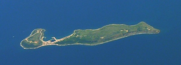 Hujing Island
 Map of Penghu (the Pescadores) including Hujing Island (labeled as Groote Taaffel) (circa 1726)
 Map of Hujing Island (labeled as Kosei-tō) and surrounding area (AMS, 1944)
 Map including Hujing Island (labeled as Hu-ching hsü (Kosei-sho) 虎井嶼) (AMS, 1950)


頂桌與翹頭案.jpg)
.jpg)


See also
References
External links
Wikiwand - on
Seamless Wikipedia browsing. On steroids.
Remove ads