Top Qs
Timeline
Chat
Perspective
Kirby Grindalythe
Village and civil parish in North Yorkshire, England From Wikipedia, the free encyclopedia

Remove ads
Kirby Grindalythe is a village and civil parish in North Yorkshire, England. It is situated about 8 miles (13 km) south-east of Malton. The village lies in the Great Wold Valley and the course of the winterbourne stream the Gypsey Race passes through it.
Apr2006.jpg)
.svg)
Remove ads
History
Summarize
Perspective
The name of the village is derived from Old Norse. Kirby kirkiubỹr means "village with a church", the Grindal element is a distortion of Cranedale, meaning "valley with cranes" and lythe is from Old Norse "hlíõ" meaning slope.[2] Kirby Grindalythe was mentioned in the Domesday Book as being in the Hundred of Toreshou (Buckrose), belonging to King William, and having one ploughland.[3] The settlement was built around its parish church in the upper Gypsey Race Valley, and in Medieval times, it was the most important settlement in the area.[4]
Kirby Grindalythe village has a resident population of roughly fifty. There are no shops, pubs or other services and the nearest town is Malton. St Andrew's Church, Kirby Grindalythe is on the Sykes Churches Trail having been restored by Sir Tatton Sykes in 1872–5 and again more recently after a grant of about £175,000 from English Heritage.[5] The church is now a Grade II* listed building.[6]
The village is also the location of the Cranedale Centre, a residential Field Studies Centre providing courses in environmental subjects and outdoor education to people of all ages. The centre operates from a converted farm and has been open since 1983.[7]
Remove ads
Governance
The civil parish of Kirby Grindalythe, which includes the village of Duggleby, had a population of 247 people living in 92 households at the time of the 2001 Census.[8] The population at the 2011 Census had risen to 295.[1] In 1823 Kirby Grindalythe was a civil parish with a population of 178 in the Wapentake of Buckrose.[9] It was historically part of the Norton Rural District in the East Riding of Yorkshire until 1974.[10] Between 1974 and 2023 the parish was part of the Ryedale district. It is now administered by North Yorkshire Council.[11][12] It is represented at Westminster as part of the Thirsk and Malton Constituency.[13]
| 1801 | 1811 | 1821 | 1831 | 1841 | 1851 | 1861 | 1871 | 1881 | 1891 | 1901 | 1911 | 1921 | 1931 | 1951 | 1961 | 1971 | 1981 | 1991 | 2001 | 2011 | 2015 |
|---|---|---|---|---|---|---|---|---|---|---|---|---|---|---|---|---|---|---|---|---|---|
| 276 | 311 | 376 | 414 | 474 | 554 | 571 | 566 | 534 | 449 | 415 | 411 | 359 | 332 | 327 | 303 | 291 | 290 | 284 | 247 | 295 | 350[a] |
Remove ads
High Mowthorpe
Also in the civil parish is the former hamlet of High Mowthorpe (54.10819°N 0.64231°W ),[17] which is now an ADAS farm and arable research centre. The farm is a mixed arable and livestock farm, covering 437 hectares (1,080 acres) with 97 hectares (240 acres) managed organically.[18] Laboratory and glasshouse facilities are located on the site as well as a weather station providing data to the Met Office.[19] High Mowthorpe is also the home of ADAS Pest Evaluation Services, which processes approximately 4,000 soil and plant samples annually to determine pest and disease levels.
See also
Gallery
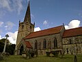 St Andrew's Church
 Interior of St Andrew's
.jpg)
.jpg)
References
External links
Wikiwand - on
Seamless Wikipedia browsing. On steroids.
Remove ads