Top Qs
Timeline
Chat
Perspective
List of Indian states and union territories by elevation
From Wikipedia, the free encyclopedia
Remove ads
This list includes the topographic elevations of each of the 28 states 8 union territories of India.
The elevation of a geographic area may be stated in several ways. These include:
- The maximum elevation of the area (high point);[a]
- The minimum elevation of the area (low point);[b]
- The arithmetic mean elevation of the area (statistical mean elevation);[c]
- The median elevation of the area (statistical 50% elevation);[d] and
- The elevation range of the area.[e]
Remove ads
Elevations
Summarize
Perspective
Remove ads
Highpoint gallery
 Kangchenjunga (8,586 m)
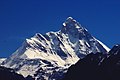 Nanda Devi (7,817 m)
 Saltoro Kangri (7,742 m)
 Nun Kun (7,135 m)
 Kangto (7,090 m)
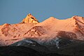 Reo Purgyil (6,816 m)
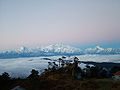 Sandakphu (3,636 m)
 Anamudi (2,695 m)
 Guru Shikhar (1,722 m)
 Kalsubai (1,646 m)


.jpg)


See also
Notes
- A high point may be (1.) a topographic summit, or (2.) a point on a border.
- A low point may be (1.) the border crossing of a gulch, stream, or river; or (2.) the shore of a reservoir, lake, or ocean; or (3.) the bottom of an endorheic basin. The elevation of a stream, river, reservoir, or lake will vary seasonally. The bottom of an endorheic basin may fill with water.
- The mean elevation of an area is the arithmetic average of all point elevations in the area.
- The median elevation of an area is the median of all point elevations in the area.
- The elevation range of an area is the maximum elevation minus the minimum elevation.
Remove ads
References
Wikiwand - on
Seamless Wikipedia browsing. On steroids.
Remove ads