| Name |
Location |
Province/Region |
Date of Completion |
Ownership / Built by |
Image |
Notes |
|---|
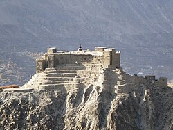
| Baghsar Fort |
Bhimber District |
Azad Kashmir |
|
Mughal Empire[1] |
 |
Currently closed to visitors, due to it being right beside Line of Control between Pakistan and India.[2] |
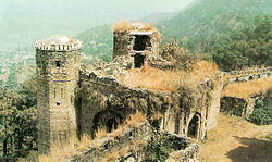
| Throchi Fort |
Kotli District |
Azad Kashmir |
1460 |
|
 |
|
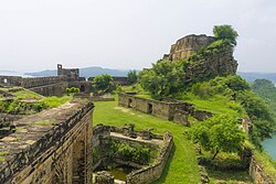
| Ramkot Fort |
Mirpur District |
Azad Kashmir |
16–17th Century |
Gakhars |
 |
|
| Red Fort, Muzaffarabad |
Muzaffarabad District |
Azad Kashmir |
1646 |
Sultan Muzaffar Khan |
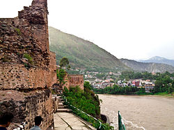 |
Locally, it is known as the "Rutta Qila" or just "qila". |
| Karjai Fort |
Kotli District |
Azad Kashmir |
|
|
|
[3] |
| Mangla Fort |
Mirpur District |
Azad Kashmir |
|
|
 |
|
| Zhob Fort |
Zhob District |
Balochistan |
1867 |
British Raj |
|
Also known as Sandeman Fort.[4] |
| Kharan Fort |
Kharan District |
Balochistan |
|
|
 |
|
| Sandeman Fort |
Zhob District |
Balochistan |
|
|
|
|
| Kalat Fort |
Kalat District |
Balochistan |
|
Khanate of Kalat |
 |
The town of Kalat is said to have been founded by and named Qalat-e Sewa (Sewa's Fort), after Sewa, a legendary hero of the Baloch people.[5] |
| Sassi Punnu Fort |
Turbat District |
Balochistan |
|
|
 |
Also known as "Meeri Kalaat".[6] Location 26°2′2″N 63°00′46″E |
| Sibi Fort |
Sibi District |
Balochistan |
|
|
 |
[7] |
| Baltit Fort |
Hunza District |
Gilgit Baltistan |
|
|
 |
Since 2004, it has been on the UNESCO World Heritage Tentative list. |
| Skardu Fort |
Skardu District |
Gilgit Baltistan |
|
|
 |
|
| Altit Fort |
Hunza District |
Gilgit Baltistan |
11th Century |
|
 |
|
| Shigar Fort |
Shigar District |
Gilgit Baltistan |
17th Century |
Amacha Dynasty |
 |
The Shigar Fort means The Fort on Rock. |
| Khaplu Fort |
Ghanche District |
Gilgit Baltistan |
|
|
 |
It is locally known as Yabgo Khar, meaning "The fort on the roof". |
| Kalam Darchi Fort |
Hunza District |
Gilgit Baltistan |
1933 |
British Raj |
|
This fort was named after a naked saint and was built by British soldiers during 1932–33 to check the invasion and inflow of people from China and USSR through Wahkan corridor. It remained the abode of Gilgit Scouts.[8] |
| Shagai Fort |
Khyber District |
Khyber Pakhtunkhwa |
1927 |
|
 |
|
| Harkishan Garh Fort |
Haripur District |
Khyber Pakhtunkhwa |
1822–23 |
Sikh Empire |
|
|
| Fort Munro |
D.G.Khan |
Punjab |
1800 |
British Raj |
 |
Locally, it is known as the "South Punjab Murree". |
| Bala Hisar Fort |
Peshawar District |
Khyber Pakhtunkhwa |
|
|
 |
also known as Qila Balahisar |
| Chitral Fort |
Chitral District |
Khyber Pakhtunkhwa |
Chitral State |
|
 |
[9]35°51′19″N 71°47′30″E |
| Mastuj Fort |
Chitral District |
Khyber Pakhtunkhwa |
|
|
 |
[10] |
| Chakdarra Fort |
Lower Dir District |
Khyber Pakhtunkhwa |
1586 |
Mughal Empire |
 |
The Mughals built a fort here in 1586, occupied in 1895 by the British, who built the present fort in 1896.[11] 34°38′50″N 72°01′42″E |
| Birmoghlasht Summer Fort |
Lower Chitral District |
Khyber Pakhtunkhwa |
|
|
|
|
| Malakand Fort |
Malakand District |
Khyber Pakhtunkhwa |
|
|
 |
|
| Handyside Fort |
Kohat District |
Khyber Pakhtunkhwa |
|
British Raj |
 |
|
| Jamrud Fort |
Khyber District |
Khyber Pakhtunkhwa |
1836 |
Sikh Empire |
 |
|
| Ali Masjid Fort |
Khyber District |
Khyber Pakhtunkhwa |
1837 |
Dost Mohammad Khan |
 |
|
| Sangni Fort |
Rawalpindi District |
Punjab |
19th Century |
Sikh Empire |
|
|
| Sialkot Fort |
Sialkot District |
Punjab |
2nd Century |
Raja Sálbán |
 |
|
| Attock Fort |
Attock District |
Punjab |
1583 |
Mughal Emperor Akbar |
 |
Attock Fort was built at Attock Khurd during the reign of Akbar the Great from 1581 to 1583 under the supervision of Khawaja Shamsuddin Khawafi to protect the passage of the River Indus. |
| Rohtas Fort |
Jhelum District |
Punjab |
16th Century |
Sher Shah Suri |
 |
|
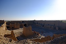
| Derawar Fort |
Bahawalpur District |
Punjab |
Rajput |
|
 |
|
| Lahore Fort |
Lahore District |
Punjab |
1605 |
Mughal Emperor Akbar |
 |
|
| Malot Fort |
Chakwal District |
Punjab |
1527 |
Mughal Emperor Babur |
 |
|
| Pharwala Castle |
Rawalpindi District |
Punjab |
15th Century |
Gakhars |
 |
|
| Sheikhupura Fort |
Sheikhupura |
Punjab |
1607 |
Mughal Emperor Jahangir |
 |
[12] |
| Rawat Fort |
Rawalpindi District |
Punjab |
|
Gakhars |
 |
|
| Islamgarh Fort |
Rahim Yar Khan District |
Punjab |
1665 |
Raja Rawal Siri Bheem SinghRajput |
 |
[13] |
| Moj Garh Fort |
Bahawalnagar District |
Punjab |
|
Rajput |
 |
[14] |
| Bijnot Fort |
Bahawalpur District |
Punjab |
|
|
 |
|
| Deen Garh Fort |
|
|
|
|
|
[15] |
| Multan Fort |
Multan District |
Punjab |
800 - 1000 BC |
|
 |
The fort was destroyed by British forces. |
| Mankera Fort |
Bhakkar District |
Punjab |
|
|
 |
|
| Marot Fort |
Bahawalnagar District |
Punjab |
|
|
|
A ruined fortress town.[16] 29°10′37″N 72°26′00″E |
| Fort Abbas |
Bahawalnagar District |
Punjab |
|
|
|
|
| Nandana Fort |
Jhelum District |
Punjab |
|
|
 |
Al-Beruni (973-1053 AD), the celebrated traveler, historian, philosopher, mathematician, astronomer and scientist, came to the subcontinent in the period of Mehmood of Ghazni during the 11th century. It was at Nandana, that he measured the circumference of the earth.[17] |
| Satghara |
Okara District |
Punjab |
|
|
 |
It is also believed to be the location of the tomb of Baloch king, Mir Chakar Rind (1468–1565). |
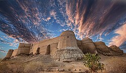
| Kot Diji Fort |
Khairpur District |
Sindh |
1795 |
Mir Sohrab Khan Talpur |
 |
|
| Ranikot Fort |
Jamshoro District |
Sindh |
17th Century |
|
 |
Ranikot Fort is also known as The Great Wall of Sindh and is believed to be the world's largest fort with a circumference of approximately 26 kilometres (16 mi).[18] Since 1993, it has been on the tentative list of UNESCO World Heritage Sites.[19] |
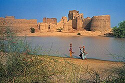
| Naukot Fort |
Tharparkar District |
Sindh |
|
|
 |
|
| Bukkur Fort |
Sukkur District |
Sindh |
|
|
 |
27°41′46″N 68°53′3″E |
| Dalel Dero Fort |
Shaheed Benazirabad District |
Sindh |
|
|
|
|
| Sehwan Fort |
Jamshoro District |
Sindh |
|
|
|
|
| Qasim Fort |
Karachi District |
Sindh |
18th Century CE |
Talpur dynasty |
 |
|
| Pacco Qillo |
Hyderabad District |
Sindh |
1768 |
Mian Ghulam Shah Kalhoro |
 |
|
| Umerkot Fort |
Umerkot District |
Sindh |
|
Rajput |
 |
|


.jpg)


