| Name |
Image |
Location |
Denomination/
Affiliation |
Grade |
Notes |
Refs |
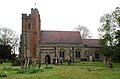
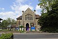
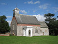
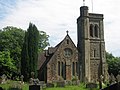
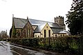
| St Peter and St Paul's Church |
 |
Ash
51.3574°N 0.2996°E / 51.3574; 0.2996 (St Peter and St Paul's Church, Ash) |
Anglican |
I |
Thomas Graham Jackson's "sympathetic" alterations of 1901–03 did little to change the appearance of the flint and sandstone 14th/15th-century church, whose dressings are mostly of a colourful red brick. There is much Decorated and Perpendicular Gothic detail throughout. |
[40][41]
[42] |
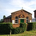
| Bessels Green Baptist Church |
 |
Bessels Green
51.2783°N 0.1588°E / 51.2783; 0.1588 (Bessels Green Baptist Chapel, Bessels Green) |
Baptist |
II |
The chapel is near the village's most prominent house, the Victorian-era Bessels House, but is a century older. The manse adjoins; it has square-headed rather than arched windows and a dormer in the tiled roof, but otherwise blends in with the painted brick chapel. Additions in the 19th century include two porches with bargeboards. |
[40][43]
[44][45] |
| Unitarian Meeting House |
 |
Bessels Green
51.2795°N 0.1622°E / 51.2795; 0.1622 (Unitarian Meeting House, Bessels Green) |
Unitarian |
II |
Like the Baptist chapel, this is 18th-century and has a house attached. It originated in 1716 but was rebuilt in 1740, retaining some of the older fabric. The chapel is single-storey and has a three-casement window façade. Mixed red and blue brickwork and some stonework make up the walls. The two-bay single-storey house was extended in the 19th century. The tiled roof is hipped and steeply sloping. |
[40][44]
[46][47] |
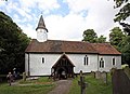
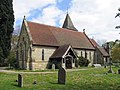
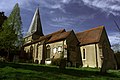
| St Martin's Church |
 |
Brasted
51.2796°N 0.1043°E / 51.2796; 0.1043 (St Martin's Church, Brasted) |
Anglican |
II* |
The 13th-century church (which contained some older fabric) was rebuilt by Alfred Waterhouse in 1864–65 and restored again after World War II (when the windows were bombed out) and in 1989 following fire damage. The walls are of sandstone, and there is a heavily buttressed west tower. Inside are some 17th-century alabaster monuments. Some of the windows have "outstanding and innovative" tracery designed by Waterhouse. |
[40][48]
[49][50] |
| St Botolph's Church |
 |
Chevening
51.2989°N 0.1347°E / 51.2989; 0.1347 (St Botolph's Church, Chevening) |
Anglican |
I |
The church has Saxon origins, but the present building is mostly 13th-century and the Perpendicular Gothic tower dates from after 1518. W. D. Caroe's restoration of 1901–02 added to some changes made in 1869. Inside, an "outstanding" collection of monuments spanning several centuries are associated with nearby Chevening House. Flint, rubble and local ragstone are the main materials. |
[40][51]
[52][53] |
| St Mary's Church |
 |
Chiddingstone
51.1863°N 0.1462°E / 51.1863; 0.1462 (St Mary's Church, Chiddingstone) |
Anglican |
II* |
A fire in 1624 prompted rebuilding of this 14th-century church over the next five years. Evidence of 13th-century lancet windows survives, and there was a church here in Saxon times. The ornately decorated tower is Perp. Internal fittings by George Edmund Street and Thomas Earp and stained glass by Charles Eamer Kempe are also of interest. |
[40][54]
[55] |
| St Luke's Church |
 |
Chiddingstone Causeway
51.1975°N 0.1758°E / 51.1975; 0.1758 (St Luke's Church, Chiddingstone Causeway) |
Anglican |
II* |
John Francis Bentley's only Anglican church is loosely Decorated Gothic Revival in style, dates from 1897 to 1898 and replaced a tin tabernacle. The tower is wide and short, the Bath Stone blocks "meticulously laid" and the windows "placed with fastidious whimsy". The east window (1906) is German Expressionist in style. |
[40][56]
[57][58] |
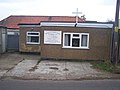
| Chapel of the Good Shepherd |
 |
Chipstead
51.2831°N 0.1499°E / 51.2831; 0.1499 (Chapel of the Good Shepherd, Chipstead) |
Anglican |
– |
This is a chapel of ease in the parish of St Botolph's Church, Chevening. Services are held at 8.00am on Sundays. |
[40][59]
[60] |
| St Mary Magdalene's Church |
 |
Cowden
51.1448°N 0.0948°E / 51.1448; 0.0948 (St Mary Magdalene's Church, Cowden) |
Anglican |
I |
The church is principally Decorated Gothic in style, with some Perpendicular Gothic elements. The nave was built first in the 13th century, followed by the chancel (late 13th- or early 14th-century) and the tower and its crooked spire (15th-century). Many of the internal fittings are of the same era. John Whichcord added an aisle and a gallery in 1838; a further restoration (1884 by W.O. Milne) took out the iron columns he added. World War II bomb damage to the spire has been repaired. |
[61][62] |
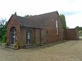
| All Souls Church |
 |
Crockenhill
51.3831°N 0.1626°E / 51.3831; 0.1626 (All Souls Church, Crockenhill) |
Anglican |
II |
Edwin Nash designed this church in the Early English Gothic Revival style in 1851 using local ragstone and Caen stone. The nave and chancel are of different heights. There is no tower or steeple, but a clock face has been inserted in the gable end of the west elevation. The internal fittings are "virtually complete" and include stained glass of 1853 and a Henry Willis organ of 1856. |
[40][63]
[64][65] |
| Crockenhill Baptist Church |
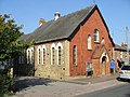 |
Crockenhill
51.3835°N 0.1640°E / 51.3835; 0.1640 (Crockenhill Baptist Church, Crockenhill) |
Baptist |
– |
Under the name Crockenhill Baptist Chapel, this building was legally registered for marriages in July 1879. An earlier chapel had served the village since 1801. |
[40][66]
[67][68] |
| Holy Trinity Church |
 |
Crockham Hill
51.2374°N 0.0674°E / 51.2374; 0.0674 (Holy Trinity Church, Crockham Hill) |
Anglican |
II |
Only the builders of this 1842 church—locally based Mr Horseman and son—and its sponsor, Charles Warde of Westerham, are known: the architect responsible for the "archaeologically faithful, though rather severe" Perpendicular Gothic Revival design has not been recorded. The nave and chancel are unequal in height, and a tower rises at the west end. Local stone was used throughout. Inside, Octavia Hill is commemorated by a carving dated 1912. |
[40][65]
[69][70] |
| Dunton Green Free Church |
 |
Dunton Green
51.2925°N 0.1682°E / 51.2925; 0.1682 (Dunton Green Free Church, Dunton Green) |
Congregational Federation |
– |
Congregationalists built a church on London Road in the village in 1873, but it passed to another denomination when this new building on Station Road was finished in 1937. The first service was held on 30 September 1937. The church was linked to Sevenoaks Congregational Church until the 1960s. |
[40][71]
[72][73] |
| St Peter and St Paul's Church |
 |
Edenbridge
51.1961°N 0.0666°E / 51.1961; 0.0666 (St Peter and St Paul's Church, Edenbridge) |
Anglican |
I |
There is much 13th- and 14th-century fabric in this long, low sandstone-built church, and the south chapel (a memorial to Richard Martyn) can be precisely dated to 1499. An Early English Gothic tower with a pyramidal spire dominates the west end. The elaborate pulpit is of the 1630s. |
[40][74]
[75][76] |
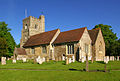
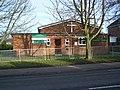
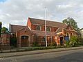
| The Eden Church |
 |
Edenbridge
51.1948°N 0.0659°E / 51.1948; 0.0659 (The Eden Church, Edenbridge) |
Baptist |
– |
|
[40][77]
[78][79]
[80][81] |
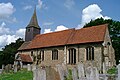
| St Lawrence's Church |
 |
Edenbridge
51.1980°N 0.0639°E / 51.1980; 0.0639 (St Lawrence's Church, Edenbridge) |
Roman Catholic |
– |
The town's Roman Catholic church stands on the High Street and is dedicated to Lawrence the Martyr. Its marriage registration dates from February 1933. Before the church opened in that year, Edenbridge's Roman Catholics travelled across the county boundary to All Saints Church in Oxted, Surrey. |
[40][82]
[83][84]
[85] |
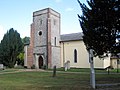
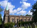
| St Martin of Tours' Church |
 |
Eynsford
51.3674°N 0.2116°E / 51.3674; 0.2116 (St Martin of Tours' Church, Eynsford) |
Anglican |
I |
Some 12th-century work survives in this flint and stone church (such as two windows in the chancel), but there are parts from each of the next four centuries and the building was restored in the Victorian era. An original apse and side chapel have been lost, but a cross-gabled aisle was added in the 16th century. |
[40][86]
[87] |
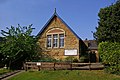
| Eynsford Baptist Church |
 |
Eynsford
51.3699°N 0.2145°E / 51.3699; 0.2145 (Eynsford Baptist Church, Eynsford) |
Baptist |
– |
There was an older Baptist church in this village, which was closed and replaced by the present building in around December 1907. The original chapel had been registered for marriages in August 1837. |
[40][88]
[89][90] |
| St Peter and St Paul's Church |
 |
Farningham
51.3801°N 0.2218°E / 51.3801; 0.2218 (St Peter and St Paul's Church, Farningham) |
Anglican |
I |
A "well-proportioned tower of the Kentish type", with stepped corner buttresses and rising in three stages to a castellated top with an octagonal corner turret, is the principal original feature here. John Shaw, Sr. and Ewan Christian carried out extensive restorations in 1830 and 1868–71 respectively. In the churchyard, Thomas Nash—uncle of architect John Nash—is buried in an elaborate cube-shaped mausoleum possibly designed by his nephew. |
[40][91]
[92] |
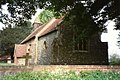
| St Mary's Church |
 |
Fawkham
51.3890°N 0.2939°E / 51.3890; 0.2939 (St Mary's Church, Fawkham) |
Anglican |
I |
This tiny chapel, in a wooded setting, has rendered walls and painted stonework around the windows, a large wooden porch and a tall weatherboarded bellcote on the tiled roof. This dates from the 16th century and is topped with a spike-like spire. There is 13th- and 14th-century work inside, including a mural of Christ in Majesty. |
[40][93]
[94] |
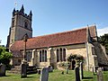
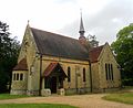
| St Peter's Church |
 |
Fordcombe
51.1421°N 0.1791°E / 51.1421; 0.1791 (St Peter's Church, Fordcombe) |
Anglican |
II |
Built 1847–1848 by Henry Isaac Stevens, the east end is modelled after Skelton Church in North Yorkshire. A deep, gabled north east vestry was added in 1883 by E. J. Tarver, and stained glass windows designed by H. W. Lonsdale were added in the north and south of the nave between 1883 and 1895, as well as in the east side of the chancel in 1906, designed by Percy Bacon and Bros. The latter was supervised by Fellowes Prynne, who also completed work on the screen in 1906. |
[40][95]
[96][97] |
| St Paul's Church |
 |
Four Elms
51.2144°N 0.1034°E / 51.2144; 0.1034 (St Paul's Church, Four Elms) |
Anglican |
II |
Built 1880–1881 by E. T. Hall, the nave and chancel are combined. Fittings include a white marble reredos from 1917, as well as choir stalls and a chancel screen designed in 1915, all designed by Lethaby with the former executed by Stirling Lee and Henry Pegram. The organ case by F. C. Eden dates to 1923, and a set of Clayton and Bell stained glass windows reside in the east side of the chancel, built between 1881 and 1887. |
[40][98]
[99][100] |
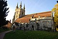
| St Margaret's Church |
 |
Halstead
51.3352°N 0.1285°E / 51.3352; 0.1285 (St Margaret's Church, Halstead) |
Anglican |
II |
The chancel dates to 1855, designed by R. C. Hussey and built as a burial chapel. The nave was built 1880–1881 by W. M. Teulon, and the north aisle and vestry were added by St Aubyn and Wadling in 1897, with the outer north aisle dating to 1992. Monuments inside the church date to the 15th century, remnants of the previous medieval church demolished circa 1881. |
[40][101]
[102][103]
[104] |
| All Saints Church |
 |
Hartley
51.3761°N 0.3165°E / 51.3761; 0.3165 (All Saints Church, Hartley) |
Anglican |
I |
The nave is 12th-century and the lower, diagonally buttressed chancel dates from one or two centuries later, and most other external features are 19th-century. "The only memorable feature" inside or out, according to architectural historian John Newman, is the Norman hingework on the door. Many old and elaborate gravestones can be seen in the churchyard. |
[40][105]
[106][107] |
| All Saints Church Centre |
 |
Hartley
51.3825°N 0.3063°E / 51.3825; 0.3063 (All Saints Church Centre, Hartley) |
Anglican |
– |
This modern building is used as a church and hall, and is one of three churches in the parish of Fawkham and Hartley. |
[108] |
| St Francis De Sales' Church |
 |
Hartley
51.3856°N 0.3089°E / 51.3856; 0.3089 (St Francis De Sales' Church, Hartley) |
Roman Catholic |
II |
Hartley's Roman Catholic church, which was opened in 1913 registered for marriages in July 1938, occupies a Grade II-listed 17th-century barn with internal timber framing and a queen post roof. The interior has aisles and is divided into three bays, and the thatched roof has a pentice. The barn was originally part of Middle Farm. |
[40][107]
[109][110]
[111] |
| St Peter's Church |
 |
Hever
51.1800°N 0.1066°E / 51.1800; 0.1066 (St Peter's Church, Hever) |
Anglican |
I |
Built out of sandstone, the earliest identifiable section is the arcade to the north aisle, dated to around the early 13th century. The southern nave wall, as stated by John Newman, dates to the 13th century or earlier due to the lack of a plinth. The church was restored in 1894 by R. P. Day, which includes perpendicular two-light windows inserted in the nave, north aisle and southern porch. A chantry was permitted to Sir Geoffrey Bullen in the north chapel in 1465, although the basket-arched east windows as well as the west and south arches firmly date the chapel to the early 16th century. |
[40][112]
[113] |
| St Peter's Church |
 |
Hextable
51.4108°N 0.1815°E / 51.4108; 0.1815 (St Peter's Church, Hextable) |
Anglican |
– |
Hextable's Anglican church is in the parish of St Paul's Church, Swanley Village. The brick-walled, slate-roofed building consists of the original Hextable Mission Church, founded by St Paul's in 1905, and an octagonal extension built in 1980. |
[40][114]
[115] |
| Hextable Methodist Church |
 |
Hextable
51.4088°N 0.1822°E / 51.4088; 0.1822 (Hextable Methodist Church, Hextable) |
Methodist |
– |
This brick chapel was built for Wesleyan Methodists in 1896 at a cost of £434. Under the name Wesleyan Methodist Chapel, it was registered for marriages in May 1913. |
[40][116]
[117][118] |
| St Mary's Church |
 |
Horton Kirby
51.3946°N 0.2439°E / 51.3946; 0.2439 (St Mary's Church, Horton Kirby) |
Anglican |
II* |
|
[40][119]
[120][121]
[122] |
| St Mary's Church |
 |
Ide Hill
51.2451°N 0.1279°E / 51.2451; 0.1279 (St Mary's Church, Ide Hill) |
Anglican |
II* |
|
[40][123]
[124][125] |
| St Mary's Church |
 |
Kemsing
51.3069°N 0.2310°E / 51.3069; 0.2310 (St Mary's Church, Kemsing) |
Anglican |
II* |
|
[40][126]
[127] |
| St Mary's Church |
 |
Kippington, Sevenoaks
51.2702°N 0.1797°E / 51.2702; 0.1797 (St Mary's Church, Kippington, Sevenoaks) |
Anglican |
II |
|
[40][128]
[129][130] |
| St Katherine's Church |
 |
Knockholt
51.3106°N 0.1046°E / 51.3106; 0.1046 (St Katherine's Church, Knockholt) |
Anglican |
II* |
|
[40][131]
[132] |
| London Road Evangelical Church |
 |
Knockholt Pound
51.3170°N 0.1266°E / 51.3170; 0.1266 (London Road Evangelical Church, Knockholt Pound) |
Evangelical |
– |
John Wills, a Derby-based Nonconformist church architect, designed this simple yellow-brick building on the old London Road in Knockholt in 1887. William Wiltshire was the builder, and the cost was £981. Provided for Wesleyan Methodists, it replaced a timber chapel of 1825 and was named the Townend Memorial Chapel. It was sold to an Evangelical congregation in 1968. |
[40][133]
[134][135]
[136] |
| St Mary's Church |
 |
Leigh
51.1977°N 0.2152°E / 51.1977; 0.2152 (St Mary's Church, Leigh) |
Anglican |
II* |
|
[40][137]
[138] |
| St Botolph's Church |
 |
Lullingstone
51.3584°N 0.1959°E / 51.3584; 0.1959 (St Botolph's Church, Lullingstone) |
Anglican |
I |
|
[40][139]
[140] |
| Holy Trinity Church |
 |
Markbeech
51.1652°N 0.1079°E / 51.1652; 0.1079 (Holy Trinity Church, Markbeech) |
Anglican |
II |
|
[40][141]
[142][143] |
| Kingdom Hall |
 |
Marsh Green
51.1808°N 0.0576°E / 51.1808; 0.0576 (Kingdom Hall, Marsh Green) |
Jehovah's Witnesses |
– |
This Kingdom Hall was registered for marriages in February 1999. It is used by the Oxted Congregation of Jehovah's Witnesses; the town of Oxted is in the neighbouring county of Surrey. |
[144][145] |
| St John's United Reformed Church |
 |
Marsh Green
51.1804°N 0.0572°E / 51.1804; 0.0572 (St John's United Reformed Church, Marsh Green) |
United Reformed Church |
– |
Greybury Presbyterian Church and its adjoining school, which also survives, were opened by J.T. Morton on 21 June 1882. Architecturally the complex is Early English Gothic Revival and features bands of red and white brick with some stonework, a slate roof and a corner tower with a spire. The windows have tracery. The church is now part of the United Reformed Church. |
[40][79]
[146][147] |
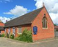
| Ash Chapel |
 |
New Ash Green
51.3641°N 0.2968°E / 51.3641; 0.2968 (Ash Chapel, New Ash Green) |
Evangelical |
– |
|
[40][148]
[149][150] |
| St Bartholomew's Church |
 |
Otford
51.3124°N 0.1917°E / 51.3124; 0.1917 (St Bartholomew's Church, Otford) |
Anglican |
I |
|
[40][151]
[152] |
| Otford Evangelical Free Church |
 |
Otford
51.3118°N 0.1742°E / 51.3118; 0.1742 (Otford Evangelical Free Church, Otford) |
Evangelical |
– |
Standing on Pilgrims Way West, this was registered for marriages April 1959 under the name Pilgrims Way Chapel. |
[40][153]
[154] |
| Otford Methodist Church |
 |
Otford
51.3133°N 0.1861°E / 51.3133; 0.1861 (Methodist Church, Otford) |
Methodist |
– |
This building on the north side of Otford's main street replaces an older building on the other side of the road, which survives in secular use. The new church was registered for marriages in August 1936. |
[40][155]
[156] |
| Church of the Most Holy Trinity |
 |
Otford
51.3127°N 0.1835°E / 51.3127; 0.1835 (Church of the Most Holy Trinity, Otford) |
Roman Catholic |
– |
Otford's Roman Catholic church was registered for marriages in February 1981. |
[40][157]
[158] |
| St John the Baptist's Church |
 |
Penshurst
51.1736°N 0.1834°E / 51.1736; 0.1834 (St John the Baptist's Church, Penshurst) |
Anglican |
I |
|
[40][159]
[160] |
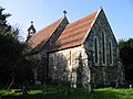
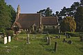
| All Souls Chapel |
 |
Poundsbridge
51.1541°N 0.1961°E / 51.1541; 0.1961 (All Souls Chapel, Poundsbridge) |
Anglican |
– |
Mervyn Edward Macartney's "uneventful" Early English Gothic Revival-style rebuild of an 1854 cemetery chapel was completed in 1889. It later became an Anglican chapel of ease in Penshurst parish. The sandstone building has lancet windows, a bellcote and a tiled roof. |
[130][161] |
| St Peter's Church |
 |
Ridley
51.3536°N 0.3196°E / 51.3536; 0.3196 (St Peter's Church, Ridley) |
Anglican |
II* |
|
[162][163] |
| St Mary's Church |
 |
Riverhead
51.2841°N 0.1708°E / 51.2841; 0.1708 (St Mary's Church, Riverhead) |
Anglican |
II |
|
[40][164]
[11][165] |
| St Peter and St Paul's Church |
 |
Seal
51.2906°N 0.2224°E / 51.2906; 0.2224 (St Peter and St Paul's Church, Seal) |
Anglican |
I |
|
[40][166]
[167] |
| St Lawrence's Church |
 |
Seal Chart
51.2743°N 0.2538°E / 51.2743; 0.2538 (St Lawrence's Church, Seal Chart) |
Anglican |
– |
Charles Henry Howell designed Seal Chart's church in 1867–68, but the tower dates from 1888 and was by a different architect (F.W. Hunt). W. Constable was the builder. The Perpendicular Gothic Revival church has lancet windows, sandstone walls and a tiled roof. |
[40][130] |
| St Nicholas' Church |
 |
Sevenoaks
51.2674°N 0.1934°E / 51.2674; 0.1934 (St Nicholas' Church, Sevenoaks) |
Anglican |
II* |
The current building mostly dates back to the 13th century, with the main section being rebuilt sometime in the 15th century. The earliest reference to the church is in the Textus Roffensis, compiled circa 1120. Excavation under the church building was completed in 1995 to provide more on-site space. |
[40][168]
[169][170] |
| St John the Baptist's Church |
 |
Sevenoaks
51.2833°N 0.1954°E / 51.2833; 0.1954 (St John the Baptist's Church, Sevenoaks) |
Anglican |
– |
Architects Morphew and Green originally designed the west building in 1858, with the north aisle being built in the same gothic style in 1878. The east end of the church was built using brick between 1901 and 1905, and a chancel bellcote was later added in 1939, after the First World War had disrupted plans for a complete rebuild. |
[40][130]
[171][172] |
| St Luke's Church |
 |
Sevenoaks
51.2743°N 0.1862°E / 51.2743; 0.1862 (St Luke's Church, Sevenoaks) |
Anglican |
– |
|
[40][171] |
| The Vine Baptist Church |
 |
Sevenoaks
51.2771°N 0.1940°E / 51.2771; 0.1940 (The Vine Baptist Church, Sevenoaks) |
Baptist |
– |
|
[40][130]
[173][174] |
| Vine Evangelical Church |
 |
Sevenoaks
51.2775°N 0.1933°E / 51.2775; 0.1933 (Vine Evangelical Church, Sevenoaks) |
Brethren |
– |
|
[40][175]
[176] |
| First Church of Christ, Scientist |
 |
Sevenoaks
51.2707°N 0.1898°E / 51.2707; 0.1898 (First Church of Christ, Scientist, Sevenoaks) |
Christian Scientist |
– |
|
[40][177] |
| Hope Church (Sevenoaks Town Church) |
 |
Sevenoaks
51.2888°N 0.1998°E / 51.2888; 0.1998 (Sevenoaks Town Church, Sevenoaks) |
Evangelical |
– |
|
[40][178] |
| Kingdom Hall |
 |
Sevenoaks
51.2808°N 0.1959°E / 51.2808; 0.1959 (Kingdom Hall, Sevenoaks) |
Jehovah's Witnesses |
– |
The building is now used by the Sevenoaks Congregation of Jehovah's Witnesses. Opened as Bethel Chapel in 1842 for General Baptists in an area of Sevenoaks known then as Harts Lands, it was re-registered for worship by The Salvation Army in 1919. They left by October 1967, and the Kingdom Hall was established in the premises by June 1968. |
[179][180]
[181][182]
[183] |
| The Drive Methodist Church |
 |
Sevenoaks
51.2740°N 0.1919°E / 51.2740; 0.1919 (The Drive Methodist Church, Sevenoaks) |
Methodist |
– |
|
[40][184]
[185] |
| Friends Meeting House |
 |
Sevenoaks
51.2806°N 0.1956°E / 51.2806; 0.1956 (Friends Meeting House, Sevenoaks) |
Quaker |
– |
The building was originally residential and dates from the mid-19th century. It was bought by local Quakers (who had been meeting in a church hall) in 1958, and after various alterations it opened as a meeting house in 1960 and was registered accordingly in November of that year. |
[40][182]
[186][187] |
| Church of St Thomas of Canterbury |
 |
Sevenoaks
51.2731°N 0.1864°E / 51.2731; 0.1864 (Church of St Thomas of Canterbury, Sevenoaks) |
Roman Catholic |
– |
|
[40][130]
[188][189] |
| Christ Church |
 |
Sevenoaks
51.2779°N 0.1784°E / 51.2779; 0.1784 (Christ Church, Sevenoaks) |
United Reformed Church |
– |
|
[40][190] |
| Sevenoaks United Reformed Church |
 |
Sevenoaks
51.2822°N 0.1942°E / 51.2822; 0.1942 (Sevenoaks United Reformed Church, Sevenoaks) |
United Reformed Church |
– |
|
[40][130]
[189][191]
[192] |
| St George's Church |
 |
Sevenoaks Weald
51.2405°N 0.1892°E / 51.2405; 0.1892 (St George's Church, Sevenoaks Weald) |
Anglican |
II |
|
[40][179]
[193][194] |
| Weald Methodist Church |
 |
Sevenoaks Weald
51.2363°N 0.1863°E / 51.2363; 0.1863 (Weald Methodist Church, Sevenoaks Weald) |
Methodist |
– |
The brick building has stood on the village green since 1843. The main elevation is in an elaborate Renaissance Revival style. |
[40][179]
[195] |
| St Peter and St Paul's Church |
 |
Shoreham
51.3330°N 0.1845°E / 51.3330; 0.1845 (St Peter and St Paul's Church, Shoreham) |
Anglican |
I |
|
[40][196]
[197] |
| South Darenth Village Church |
|
South Darenth
51.4010°N 0.2535°E / 51.4010; 0.2535 (South Darenth Village Church, South Darenth) |
Non-denominational |
– |
|
[121][122]
[198] |
| Southdowns Chapel |
 |
South Darenth
51.4010°N 0.2535°E / 51.4010; 0.2535 (Southdowns Chapel, South Darenth) |
Non-denominational |
– |
|
[122][125] |
| St Mary's Church |
 |
Sundridge
51.2743°N 0.1292°E / 51.2743; 0.1292 (St Mary's Church, Sundridge) |
Anglican |
I |
|
[40][199]
[200] |
| St Mary the Virgin's Church |
|
Swanley
51.3976°N 0.1720°E / 51.3976; 0.1720 (St Mary the Virgin's Church, Swanley) |
Anglican |
– |
|
[40][201]
[202] |
| Swanley Full Gospel Church |
 |
Swanley
51.4049°N 0.1568°E / 51.4049; 0.1568 (Swanley Full Gospel Church, Swanley) |
Assemblies of God |
– |
This building stands on Hockenden Lane on the edge of Swanley, and received its authorisation for certifying marriages in March 1986. |
[40][203]
[204] |
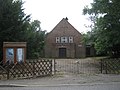
| Meeting Room |
 |
Swanley
51.4067°N 0.1630°E / 51.4067; 0.1630 (Meeting Room, Swanley) |
Brethren |
– |
Standing on Leydenhatch Lane at the north end of Swanley near Hextable, this Brethren meeting hall was registered for marriages in October 1988. |
[205][206] |
| Elim Christian Centre |
 |
Swanley
51.3947°N 0.1644°E / 51.3947; 0.1644 (Elim Christian Centre, Swanley) |
Elim Pentecostal |
– |
This Pentecostal place of worship was registered for marriages in December 1986. |
[40][207]
[208] |
| Kingdom Hall |
 |
Swanley
51.3923°N 0.1864°E / 51.3923; 0.1864 (Kingdom Hall, Swanley) |
Jehovah's Witnesses |
– |
This Kingdom Hall is used by the London, Swanley Congregation of Jehovah's Witnesses. It was registered for marriages in October 1984. |
[40][209]
[210] |
| Church of the Holy Apostles |
 |
Swanley
51.3982°N 0.1740°E / 51.3982; 0.1740 (Church of the Holy Apostles, Swanley) |
Roman Catholic |
– |
The Twelve Apostles Church Hall on London Road was used for Catholic worship in Swanley between 1931 and January 1965, at which point the present building—with a slightly amended dedication—was registered. |
[40][211]
[212] |
| Christ Church |
 |
Swanley
51.3943°N 0.1810°E / 51.3943; 0.1810 (Christ Church, Swanley) |
United Reformed Church |
– |
|
[40][213]
[214][215] |
| St Paul's Church |
 |
Swanley Village
51.4062°N 0.1978°E / 51.4062; 0.1978 (St Paul's Church, Swanley Village) |
Anglican |
II |
|
[40][201]
[216][217] |
| Toys Hill Hall |
 |
Toys Hill
51.2418°N 0.1038°E / 51.2418; 0.1038 (Toys Hill Hall, Toys Hill) |
Anglican |
– |
This building lies within the parish of Four Elms, Hever and Markbeech. |
[218] |
| St Margaret's Church |
 |
Underriver
51.2458°N 0.2292°E / 51.2458; 0.2292 (St Margaret's Church, Underriver) |
Anglican |
II |
|
[40][219]
[220][221] |
| Well Hill Mission Church |
 |
Well Hill
51.3570°N 0.1512°E / 51.3570; 0.1512 (Well Hill Mission Church, Well Hill) |
Anglican |
– |
This small chapel of ease dates from 1890 and is now administered from St Martin of Tours' Church in Chelsfield. |
[222][223] |
| St Edmund's Church |
 |
West Kingsdown
51.3508°N 0.2673°E / 51.3508; 0.2673 (St Edmund's Church, West Kingsdown) |
Anglican |
I |
|
[40][224]
[225] |
| West Kingsdown Baptist Church |
 |
West Kingsdown
51.3412°N 0.2675°E / 51.3412; 0.2675 (West Kingsdown Baptist Church, West Kingsdown) |
Baptist |
– |
|
[40] |
| King's Church |
|
West Kingsdown
51.3383°N 0.2670°E / 51.3383; 0.2670 (King's Church, West Kingsdown) |
Evangelical |
– |
|
[40] |
| St Bernadette's Church |
 |
West Kingsdown
51.3425°N 0.2683°E / 51.3425; 0.2683 (St Bernadette's Church, West Kingsdown) |
Roman Catholic |
– |
|
[40][226]
[227] |
| St Mary the Virgin's Church |
 |
Westerham
51.2676°N 0.0736°E / 51.2676; 0.0736 (St Mary the Virgin's Church, Westerham) |
Anglican |
II* |
|
[40][228]
[229] |
| Westerham Evangelical Congregational Church |
 |
Westerham
51.2676°N 0.0704°E / 51.2676; 0.0704 (Westerham Congregational Church, Westerham) |
Independent Congregational (EFCC) |
II |
|
[40][221]
[230][231]
[232][233] |
| St John the Baptist's Church |
 |
Westerham
51.2657°N 0.0775°E / 51.2657; 0.0775 (St John the Baptist's Church, Westerham) |
Roman Catholic |
– |
Priests from Sevenoaks celebrated Mass at various locations in Westerham between 1920 and 1955, when the brick-built church was opened on Hosey Hill. It was founded in April 1954, but work had started in the 1930s only to be interrupted by World War II. J. Hicks of St Leonards-on-Sea was the architect. Fr Maurice Castelli, the first priest, was a major benefactor. |
[40][234]
[235] |
| St Mary the Virgin's Church |
 |
Woodlands
51.3283°N 0.2562°E / 51.3283; 0.2562 (St Mary the Virgin's Church, Woodlands) |
Anglican |
II |
In an "amazingly remote position" at the edge of the Knatt's Valley stands this church of 1851–52 and a vicarage and school in similar style. The group of buildings was funded by Major Vincent of Guy's Hospital and was designed by Thomas Talbot Bury. The materials are flint and stone, and the roofs are tiled. |
[40][236]
[237][238] |
|


,_Kent_-_geograph.org.uk_-_324727.jpg)


.jpg)
.jpg)


,_Edenbridge.JPG)

.jpg)


.jpg)


.jpg)


.jpg)


_-_geograph.org.uk_-_1690961.jpg)
.jpg)


,_Sevenoaks.JPG)


_(Cropped).jpg)


.JPG)


.jpg)

