Top Qs
Timeline
Chat
Perspective
List of streets and squares in Cardiff
From Wikipedia, the free encyclopedia
Remove ads
This list of streets and squares in Cardiff, Wales, includes notable outdoor thoroughfares and formal public spaces in the city.
Roads
- Cathedral Road, Pontcanna
- City Road, Plasnewydd
- Cowbridge Road East and Cowbridge Road West, the main road to the west
- Newport Road, the main road to the east
Streets
- Bute Street, Butetown (Cardiff Bay)
- Caroline Street, city centre, also known as Chip Alley or Chippy Lane.
- Lloyd George Avenue, Atlantic Wharf (Cardiff Bay)
- St. Mary Street, city centre
- The Hayes, city centre
- West Grove, Roath
 Caroline Street - 'Chip Alley'/'Chippy Lane' (2010)
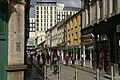
 St Mary Street, northern end (2009)
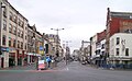 St Mary Street, southern end (2007)
 The Hayes before redevelopment (2006)
 The Hayes and St Davids 2 (2010)


Remove ads
Squares
- Callaghan Square, city centre, previously known as Bute Square.
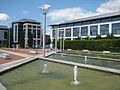
- Central Square, city centre, included the bus station between 1954 and 2015.
- Loudoun Square, Butetown
- Mount Stuart Square, Butetown
- Roald Dahl Plass, Cardiff Bay.
 Callaghan Square looking northwest (2008)
 Central Square, Cardiff railway station front (2020)
 Central Square, Cardiff (2021)
 Roald Dahl Plass (2009)


.jpg)

See also
References
Wikiwand - on
Seamless Wikipedia browsing. On steroids.
Remove ads