Top Qs
Timeline
Chat
Perspective
Los Angeles's 11th City Council district
American legislative district From Wikipedia, the free encyclopedia
Remove ads
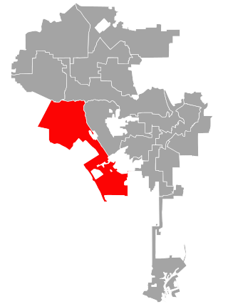
Los Angeles's 11th City Council district is one of the fifteen districts in the Los Angeles City Council. It is currently represented by Democrat Traci Park since 2022, who succeeded Mike Bonin after his retirement.
The district was created in 1925 after a new city charter was passed, which replaced the former "at large" voting system for a nine-member council with a district system with a 15-member council. The 11th District originally encompassed an area south of Downtown before being moved to the Venice area in 1928, where it has stayed since.[1][2] It is the largest district in the Los Angeles City Council by square miles.
Remove ads
Geography
Summarize
Perspective
The 11th District is bounded by Mulholland Drive on the north, the Pacific Ocean on the west, Imperial Highway on the south and roughly the 405 freeway on the east. The district covers all or a portion of the following: Brentwood, Del Rey, Mar Vista, Marina del Rey, Pacific Palisades, Palms, Playa del Rey, Playa Vista, Sawtelle, Venice, West Los Angeles, Westchester and the Los Angeles International Airport.[3]
The district overlaps California's 36th congressional district and California's 32nd congressional district as well as California's 24th and 35th State Senate districts and California's 42nd and 62nd State Assembly districts.
Historical boundaries
In 1925, when it was first mapped, it covered an area just south of Downtown, but three years later it was transferred to the Westside of the city. It originally had the district headquarters at 431 West Seventh Street, the present site of the Los Angeles Athletic Club.[4][5] In 1928, the district was moved from the downtown section of the city and transplanted to the coast region.[6] By 1933, it was scattered area due to its inclosure of county territory. Its eastern boundary is La Brea Avenue, its north boundary is Pico Boulevard, its southern boundary the city limits and its western boundary the ocean.[7][8][9][10] In 1957, it had parts of West Los Angeles, Westwood, Pacific Palisades, Brentwood, Mar Vista and Palms.[11][12] In 1960, Venice was shifted into the district from the 6th District.[13]
In 1971, it had Pacific Palisades, Brentwood, and West Los Angeles with sections of Tarzana, Encino, Rancho Park, Westdale, Mar Vista and Venice.[14] By 1997, it had 73 square miles, bisected by the Santa Monica Mountains, include ritzy hillside enclaves stretching from Woodland Hills to Encino, Pacific Palisades to Brentwood. Poorer parts of Van Nuys and the West Los Angeles flatlands are included as well.[15]
Remove ads
List of members representing the district
Remove ads
References
External links
Wikiwand - on
Seamless Wikipedia browsing. On steroids.
Remove ads


