Top Qs
Timeline
Chat
Perspective
Malegaon Fort
Fort in Malegaon, Maharashtra From Wikipedia, the free encyclopedia

Remove ads
Malegaon Fort is a land fort located in the town of Malegaon. It is located 104 km from Nashik, in Nashik district, of Maharashtra. The fort is on the north bank of the Mausam river, which is a tributary of the Girna river. It was built during the Maratha Empire.

Remove ads
History
Malegaon Fort was constructed in 1740 by Naro Shankar Raje Bahadur, general of the Peshwa. He was appointed as an agent in Malwa.[1] He was gifted 18 villages which included Malewadi.[2] Craftsmen were brought in from Surat and northern India to build the fort, the construction of which took 25 years.[3] After the fort was completed, the craftsmen settled in the town.
In 1816, a Rohilla sepoy named Dilawar Khan constructed the first Eidgah in the town.
After the fall of Trymbakgad fort on 24 May 1818, Malegaon Fort was besieged on 16 May 1818 by the East India Company.[4]
Remove ads
How to reach
The fort is located within the town of Malegaon. Malegaon is located on the Mumbai-Agra National highway NH-3. The fort is also known as the Raje Bahadur Wada. It is close to the Ramsetu bridge. The fort is open to the public between 10 am and 5 pm. At present, there is a Marathi high school in the premises of the fort.
Places to see
The fort is in good condition. The height of the inner wall is 60 feet. The fort has lofty entrance doors. The thickness of the walls is about six feet. There are two cannons at the entrance door and a hexagonal well inside the fort. It takes about an hour to see the fort.
Gallery
 Eastern gate of Malegaon fort
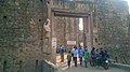 Northern gate
 Malegaon fort
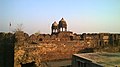 Malegaon fort
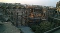 Malegaon fort
 Bastion
 Cannon on the fort


Remove ads
See also
References
Wikiwand - on
Seamless Wikipedia browsing. On steroids.
Remove ads