Top Qs
Timeline
Chat
Perspective
Mallabhum kingdom
Kingdom ruled by the Malla kings of Bishnupur, in present-day West Bengal, India From Wikipedia, the free encyclopedia

Remove ads
Mallabhum (The country originally known as Mallabhoom or Mallabani[5] Bengali: মল্লভূম or Bishnupur kingdom[6][7]) was the kingdom ruled by the Malla kings of Bishnupur, primarily in the present Bankura district in Indian state of West Bengal.

Remove ads
History
Territory of the Mallabhum
Mallabhum was a territory which included Bankura, a part of Burdwan, Birbhum, Santhal Parganas, Midnapur and also a part of Purulia. The Malla Rajas ruled over the vast territory in the south-western part of present West Bengal and a part of southeastern Jharkhand.[8]
Extent
From around 7th century CE until the advent of British rule, the history of Bankura district is identical with the rise and fall of the Hindu Rajas of Bishnupur.[citation needed]
Remove ads
Administration
Summarize
Perspective
Mahals
According to Bhattacharjee, Tarun Dev (1982) During the Malla period, society was primarily organised around the village. The tax collectors were known as Gumasta, with their assistants called Aat Pahari or Paik. The village headman, responsible for overseeing the community, was referred to as the Mukhiya or Mandal, and was considered the protector of the village. The Malla kings maintained several service groups, and due to a shortage of money, they often compensated these groups with land rather than salaries. This land was of two types: Panchaki jamin, which had a small tax, and Bepanchaki jamin, which was exempt from tax. The lands were named based on the services provided, such as.[9]
1. Senapati Mahal: Land for the head of the soldiers.
2. Mahalbera Mahal: Land for the sentries.
3. Chharidar Mahal: Land for the bodyguards.[9]
4. Jungle Mahal
According to LSS O’Malley:
Large portions of the old estate of Bishnupur were under jungle and the timber, firewood, honey, wax, etc., which they yielded, formed a valuable source of revenue. The right of collecting these jungle products was farmed out by the Raja, and the revenue he obtained thereby was called the Jungle Mahal, and had nothing to do with arable land.[10]
The Bishnupur Raj maintained a distinct Jungle Mahal, which consisted solely of forested areas, where forest resources were regularly harvested and sold.[10]
5. Ghatwals Mahal
The ghatwals were a ‘quasi military body of men employed by the Rajas of Bishnupur’ who were posted as guards at various strategic Ghats or passes in hills and uplands. They also did police duties and acted as peacekeepers. Rent-free lands given to the ghatwals by the Rajas from time to time came to be known as Ghatwali lands. Though at the time of the Permanent Settlement (between 1791 and 1802) the area of lands held by ghatwals was not known later surveys of 1854-56 and 1879-1887 estimated the area of the ghatwali land in the Bishnupur Estate to be about 170,000 acres[10]
Remove ads
Bishnupur and His Alliance with the Mughals
In the late 16th century, Bir Hambir, the ruler of Bishnupur, allied with Mughal general Man Singh during Akbar's campaign against Qutlu Khan Lohani, the Afghan ruler of North Orissa. Despite being ignored by Jagat Singh, Man Singh's son, Bir Hambir bravely rescued him from an Afghan ambush, solidifying his alliance with the Mughals. This act highlighted Bir Hambir's courage, strategic brilliance, and enduring legacy as a wise leader.[11][12]
Decline Under British Rule
Summarize
Perspective
Great Bishnupur famine of 1770
Around 1770-71, as the "great famine" swept through the region, the South Western Highlands of Bengal had transformed into a land of the dead. According to W.W. Hunter, the situation was summed up in his famous Annals of Rural Bengal:
“Before the end of 1770, one-third of the population was officially calculated to have disappeared; in June the deaths were returned as ‘six is to sixteen of the whole inhabitants’, and it was estimated that ‘one half of cultivators and payers of revenue will perish with hunger.’…in 1771, it was discovered that the remnant of the population would not suffice to till the land”.
The greatest threat to the Company was depopulation, which, despite the famine, led them to continually pressure the local rulers—the now-weakened Rajas of Bishnupur (referred to as Bishenpore by Hunter).[10] In Bishnupur, hundreds of villages were completely abandoned, and even in the larger towns, fewer than one-fourth of the houses remained occupied. Purnia and Bishnupur were the two districts in Bengal that suffered the most from the famine.[13] In 1772, Warren Hastings estimated that by that time, one-third of the population had perished.[10][14]

Rebellion at Bishnupur (1788-1809)
Between 1788 and 1809, the Chuars and Paiks of the Bishnupur and Midnapore parganas revolted against the British East India Company under the leadership of Madhav Singha Dev.[15][16]
Remove ads
List of Malla kings
Malla's started their own calendar that is Malla era (Mallabda). It is told that Malla era started from Indra Dwadasi day in the year 102 Bengali calendar of the month Bhadro (August- September).[17]
Remove ads
Temples
According to Dr. Bloch, Superintendent of the Archaeological Survey of India, Eastern Circle, the twelve date temples range in chronological order as follows:[19]
Remove ads
In popular culture
Film
- Eastern Zonal Cultural Centre, Kolkata, brings you the Fourth Documentary from 𝗢𝗻𝗹𝗶𝗻𝗲 𝗔𝗿𝗰𝗵𝗶𝘃𝗲 𝗗𝗼𝗰𝘂𝗺𝗲𝗻𝘁𝗮𝗿𝘆 𝗙𝗶𝗹𝗺 𝗙𝗲𝘀𝘁𝗶𝘃𝗮𝗹. The video is a presentation on the dhrupad gharana of Bishnupur kingdom.
Gallery
 Rasmancha (1600 CE)
 Inscription on Shyamrai Temple (1643 CE)
 Jor Mandir (1726 CE)
 Radhamadhab Temple (1737 CE)
 Kalachand Temple (1656 CE)
 Jor-Bangla Temple or Keshta Roy Temple (1655 CE)
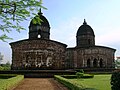 Jor Mandir complex (1726 CE)
 Madan Mohan Temple (1694 CE)
 Inscription on Radha Shyam Temple (1728 CE)
 Radha-Gobinda Temple (1729 CE)
 Shyam Ray Temple (1643 CE)
 Bishnpur fort gate
 Panchchura temple
 Stone chariot of Bishnupur
 Nandalal Temple
 Rashmancha (gate)
 Jor Bangla Temple (arches)
 Jor Bangla temple (Terracotta work)
 Jor Bangla Temple (Ramayana motifs)
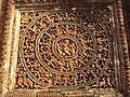 Shyamrai Temple (RasChakra)(Terracotta work)


_Arnab_Dutta_2011.JPG)


_Arnab_Dutta_2011.JPG)

_Arnab_Dutta_2011.JPG)

Remove ads
See also
- Bir Hambir
- Bishnupur
- Raghunath Singha Dev
- History of Bankura district
- History of Bengal
- Jungle Mahals
- List of rulers of Bengal
- Related to Bishnupur
References
Sources
Further reading
External links
Wikiwand - on
Seamless Wikipedia browsing. On steroids.
Remove ads