| Image | Crossing | Coordinates | Location | Built | Description | Notes |
 | Abbotsford Bridge | 34°06′50″S 141°59′17″E | Yelta to Curlwaa | 1928 | 235 metres (771 ft) long, single lane lift bridge | |
 | George Chaffey Bridge | 34°10′59″S 142°10′24″E | Mildura to Buronga | 1985 | 331 metres (1,086 ft) long, 9.8 metres (32.2 ft) wide bridge carrying the Sturt Highway | |
 | Robinvale-Euston Bridge | 34°34′40″S 142°46′3″E | Robinvale to Euston | 2006 | Replaced a single-lane lift-span road/rail bridge that was opened in 1927 as part of the abandoned Lette railway line.[permanent dead link]. | |
 | Tooleybuc Bridge | 35°01′49″S 143°20′7″E | Piangil to Tooleybuc | 1925 | timber and steel truss, single-lane restriction on lift span | |
 | Nyah Bridge | 35°10′22″S 143°23′30″E | Nyah to Koraleigh | 1941 | 104 metres (341.2 ft), central lift span | |
 | Speewa Ferry | 35°12′49″S 143°30′31″E | Speewa | | Two-car capacity, 8 tonne (8.8 t) load limit. Upstream is a private ferry to Beveridge Island (part of Victoria); it crosses a Little Murray anabranch, but that is now the main navigable channel. | |
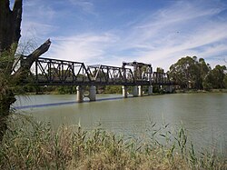
 | Swan Hill Bridge | 35°20′16″S 143°33′46″E | Swan Hill | 1896 | Two lanes except central lift span; 116 metres (380.6 ft) | |
 | Gonn Crossing Bridge | 35°30′13″S 143°57′24″E | Murrabit to Ballbank | 1926 | 103 metres (338 ft) Lift-span road/rail bridge, opened as part of the Stony Crossing railway line; road only since the railway closed in 1964. | |
 | Barham Bridge | 35°37′50″S 144°07′29″E | Koondrook to Barham | 1904 | liftspan bridge, 99 metres (325 ft) | |
 | Dhungala Bridge | 36°06′44″S 144°44′38″E | Echuca to Moama | 2022 | 622 metres (2,041 ft)[3] Cobb Highway crossing | |
 | Echuca-Moama Bridge (road) | 36°07′19″S 144°45′13″E | 1879 | built as joint road/rail bridge, bypassed in 2022, local traffic only | |
 | Echuca-Moama Bridge (rail) | 36°07′19″S 144°45′13″E | 1989 | rail | |
 | Barmah Bridge | 36°01′8″S 144°57′19″E | Barmah | 1966 | 168 metres (551.2 ft) replaced ferry[4] | |
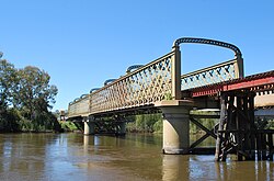
 | Tocumwal Bridge | 35°48′50″S 145°33′24″E | Tocumwal | 1895 | originally a road/rail bridge | |
 | Edward Hillson Bridge | 35°48′47″S 145°33′32″E | 1987 | Newell Highway 212 metres (695.5 ft) long, 12 metres (39.4 ft) wide | |
 | Old Cobram-Barooga Bridge | 35°54′57″S 145°40′9″E | Cobram to Barooga | 1902 | Old liftspan timber truss bridge (now pedestrian only) | |
 | Cobram-Barooga Bridge | 35°54′58″S 145°40′9″E | 2006 | New concrete bridge built immediately upstream of the old bridge | |
 | Yarrawonga Weir | 36°00′31″S 145°59′57″E | Yarrawonga to Mulwala | 1939 | Weir Road, one lane along the weir wall - originally designated as a stock route | |
 | Yarrawonga Rail Bridge | 36°00′29″S 145°59′59″E | 1989 | railway bridge, replaced earlier wooden bridge and earthen embankment | |
 | Mulwala Bridge | 36°00′20″S 146°00′18″E | 1924 | Crosses Lake Mulwala, 488 metres (1,601 ft) | |
 | John Foord Bridge | 36°00′25″S 146°23′43″E | Wahgunyah to Corowa | 1892 | retained for local traffic | |
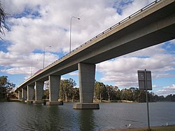
 | Federation Bridge | 35°59′8″S 146°24′40″E | 2005 | Two lanes wide and 195 metres (639.8 ft) long, with a 95 metres (311.7 ft) approach bridge on the NSW side. | |
 | John Conway Bourke Bridge | 35°59′37″S 146°37′15″E | Howlong | 2001 | | Commemorates the first carrier of mail from Sydney in 1838 to what would later be called Melbourne[5] |
 | Lincoln Causeway/Union Bridge | 36°05′29″S 146°54′23″E | Wodonga to Albury | 1961 (though first bridge opened 1861[6]) | 4 lanes, 92 metres (301.8 ft) long, widened 1990 | |
 | Albury-Wodonga Railway Bridge | 36°05′59″S 146°54′34″E | 1888 | Originally double track - one Broad gauge plus one Standard gauge. Broad gauge track disconnected following conversion of the North East Victorian broad gauge line to standard gauge in 2010. | |
 | Spirit of Progress Bridge | 36°06′02″S 146°54′34″E | 2006 | New Hume Highway bridge, named fafter the Spirit of Progress train.[7] | |
 | Island Road Bridge | 36°04′42″S 146°57′20″E | Thurgoona to the Island | | | |
 | Heywood Bridge | 36°05′57″S 147°01′19″E | Hume Dam to Bonegilla | 1984 | 124 metres (406.8 ft) long. Between Albury and here there is a bridge near the airport, to Bonegilla Island. | |
 | Bonegilla Bridge | 36°06′26″S 147°01′56″E | Hume Dam to Bonegilla | 1941 | The Hume Weir wall, now closed to motorised traffic. single lane, 91 metres (298.6 ft) | |
 | Bethanga Bridge | 36°05′25″S 147°03′31″E | Bellbridge | 1930 | on the Riverina Highway across Lake Hume | |
 | Wymah Ferry | 36°02′23″S 147°15′56″E | Wymah | | upstream end of Lake Hume, 2-car capacity, 11 tonne (12.1 t) load limit | |
 | Jingellic Bridge | 35°55′53″S 147°42′5″E | Jingellic | 1959 | 156 metres (511.8 ft) | |
 | Tintaldra Bridge | 36°2′44″S 147°55′56″E | Tintaldra | 1959 | steel truss bridge 185 metres (607 ft) | |
 | Towong Bridge | 36°7′26″S 147°59′46″E | Towong | 1938 | 61 metres (200.1 ft) long | |
 | Bringenbrong Bridge | 36°10′8″S 148°01′31″E | Bringenbrong | 1961 | 87 metres (285.4 ft) long, near Corryong on the Alpine Way | |
 | Indi Bridge | 36°14′46″S 148°02′5″E | | 1961 | Connects the Indi homestead in NSW to the Upper Murray Road. Steel girder, with concrete piles and a concrete deck. Single lane, 3.7 metres (12 ft) wide.[8] | |
 | Biggara Bridge | 36°17′46″S 148°02′17″E | Biggara | 1951 | | |
| Tom Groggin Bridge | 36.522085°S 148.136998°E / -36.522085; 148.136998 (Tom Groggin Bridge) | Tom Groggin | | Private bridges to Tom Groggin Station: low level for vehicles; higher-level suspension bridge for pedestrians when the other is flooded. | |


