Top Qs
Timeline
Chat
Perspective
Old Jamestown, Missouri
Place in Missouri, United States From Wikipedia, the free encyclopedia
Remove ads
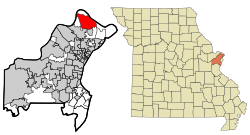
Old Jamestown is an unincorporated community and census-designated place (CDP) in St. Louis County, Missouri, United States. The population was 19,184 at the 2010 census.[4] Old Jamestown is northwest of the city of St. Louis and borders the Missouri River.
Remove ads
Geography
According to the United States Census Bureau, the CDP has a total area of 14.9 square miles (38.7 km2), of which 0.008 square miles (0.02 km2), or 0.06%, is water.[4] The community is located mostly to the north and west of U.S. Route 67 in northern St. Louis County. West Alton is to the north, across the Missouri River. Florissant is to the southwest, and Black Jack and Spanish Lake are to the south. The CDP is located 17 miles (27 km) north of downtown St. Louis.
Remove ads
Demographics
Summarize
Perspective
Old Jamestown first appeared as a census designated place in the 2010 U.S. Census.
2020 census
Remove ads
Education
The vast majority of the CDP is in the Hazelwood School District. A small portion is in the Ferguson-Florissant School District.[8]
References
External links
Wikiwand - on
Seamless Wikipedia browsing. On steroids.
Remove ads

