Top Qs
Timeline
Chat
Perspective
Oroqen Autonomous Banner
Autonomous banner in Inner Mongolia, China From Wikipedia, the free encyclopedia
Remove ads
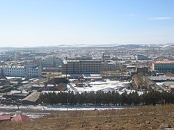
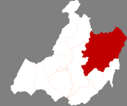
Oroqen Autonomous Banner (Oroqen: ɔrɔtʃeenŋi buwaan; Mongolian: ᠣᠷᠴᠣᠨ ᠤ ᠥᠪᠡᠷᠲᠡᠭᠡᠨ ᠵᠠᠰᠠᠬᠤ ᠬᠣᠰᠢᠭᠤ; Chinese: 鄂伦春自治旗) is an autonomous banner that lies east of the urban district of Hailar in the prefecture-level city of Hulunbuir.[2] It covers an area of 60,378 square kilometres (23,312 sq mi). As of the 2010 census[update], there were 223,752 inhabitants with a population density of 4.84 inhabitants per km2.
Remove ads
Administrative divisions
Summarize
Perspective
Oroqen Autonomous Banner is made up of 8 towns and 2 townships.[3] The banner's seat of government is located in Alihe (Ali Gol).[4]
In addition, Oroqen Autonomous Banner claims jurisdiction over Jagdaqi and Songling District; technically however, the two districts are de facto under the jurisdiction of Daxing'anling Prefecture, Heilongjiang Province. The government of Hulunbuir disputes this arrangement.[5]
Remove ads
Ethnic groups in Oroqen Autonomous Banner, 2000 census
Climate
Remove ads
References
Wikiwand - on
Seamless Wikipedia browsing. On steroids.
Remove ads


