Top Qs
Timeline
Chat
Perspective
Puerto Rico Highway 500
Highway in Puerto Rico From Wikipedia, the free encyclopedia

Remove ads
Puerto Rico Highway 500 (PR-500) is a tertiary[2] road in Ponce, Puerto Rico. The highway has both of its endpoints, as well as all of its length, entirely within the Ponce city limits. It runs east to west.

.svg)
Remove ads
Route description
Summarize
Perspective
The road has its eastern terminus at PR-132 (Calle Villa), in Barrio Canas Urbano, and its western terminus in Barrio Canas. A one-lane dirt road leads to PR-549 from there. The only major road PR-500 intersects is Avenida Baramaya (PR-9), at km 0.8. Prior to that, at km 0.3, PR-500 connects to PR-163 (Avenida Las Américas). The road ends at km 2.3, where the Vertedero Municipal de Ponce (Ponce's Municipal Waste Yard) is located. From km 2.3 an unmarked dirt road leads to PR-549, which leads to barrio Quebrada Limón in the western portion of the municipality of Ponce.
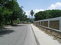 A stretch of Puerto Rico Highway 500 heading north near PR-163 in Barrio Canas
 A stretch of PR-500 heading south in Barrio Canas
 Western terminus of PR-163 at PR-500 junction in Barrio Canas Urbano, looking west
.jpg)
.jpg)
,_cerca_del_Río_Pastillo,_Bo._Canas,_Ponce,_Puerto_Rico,_mirando_al_suroeste_desde_INT_PR-163_y_PR-500_(DSC01368).jpg)
In the 2000s decade, PR-500 was no longer transited by the oversized Ponce Cement (now CEMEX) trucks. Highway 500 is about one and one-half miles long, making one of the shortest highways in Puerto Rico. It is lined by residential areas with a short section lined by the Calle Villa Final industrial park, a light-industry industrial park.
In August 2011, Senator Larry Seilhamer Rodríguez presented a bill into the Puerto Rico Senate that would extend PR-500 westward to connect with PR-2 in the area Guayanilla.[3][4]
Remove ads
History
The highway is a wide two-way roadway originally designed to accommodate the oversized trucks used by the Ponce Cement, Inc. plant in barrio Magueyes, on road PR-123. The trucks were used to transport limestone soil from the northern slopes of the western barrio Canas hills, near barrio Tallaboa in Peñuelas to the cement plant on PR-123.[5][6] The road runs from its eastern terminus at PR-132 (Calle Villa), which is the road leading from Guayanilla to Ponce through Peñuelas, to its western terminus at Barrio Canas where it ends at the Ponce Municipal Waste and Recycling Yard.
Remove ads
Major intersections
The entire route is located in Ponce.
See also
References
External links
Wikiwand - on
Seamless Wikipedia browsing. On steroids.
Remove ads