Top Qs
Timeline
Chat
Perspective
Palpa District
District in Lumbini Province, Nepal From Wikipedia, the free encyclopedia

Remove ads
Palpa District (Nepali: पाल्पा जिल्लाⓘ, a part of Lumbini Province, is one of the seventy-seven districts of Nepal, a landlocked country of South Asia. The district, with Tansen as its headquarters, covers an area of 1,373 km2 (530 sq mi) and has a population (2021) of 245,027.[1]

Palpa District is not far from Pokhara and easily reached by bus. Palpa was the seat of the Hindu Sen kingdom that ruled over this region from the 16th century for almost 300 years so the headquarter of Palpa is called "Tansen" (Nepali: तानसेन).
Remove ads
Geography and climate
Demographics
Summarize
Perspective
At the time of the 2021 Nepal census, Palpa District had a population of 245,027. 7.31% of the population is under 5 years of age. It has a literacy rate of 83.67% and a sex ratio of 1173 females per 1000 males. 91,675 (37.41%) lived in municipalities.[4]
Hill Janjatis make up 58% of the population. Magars are 53% of the population, the only district where they form a majority. Khas people make up 37% of the population, of which Khas Dalits make up 12% of the population.[5]
Languages of Palpa district (2021)[6]
- Nepali (62.2%)
- Magar (33.7%)
- Nepal Bhasha (1.81%)
- Others (2.26%)
At the time of the 2021 census, 62.24% of the population spoke Nepali, 33.69% Magar and 1.81% Nepal Bhasha as their first language.[6] In 2011, 61.9% of the population spoke Nepali as their first language.[7]
Remove ads
Local bodies
- Tansen Municipality[circular reference]
- Rampur, Palpa[circular reference]
- Rainadevi Chhahara Rural Municipality
- Ripdikot Rural Municipality
- Bagnaskali Rural Municipality
- Rambha Rural Municipality
- Purbakhola Rural Municipality
- Nisdi Rural Municipality
- Mathagadi Rural Municipality
- Tinahu Rural Municipality
Major rivers and khola
- Kali Gandaki River
- Tinau Khola
- Ridi Khola
- Purwa Khola
- Jhumsa Khola
- Dovan River
- Barabisse khola
- Dumre Khola
Major lakes
- Satyawati Lake (990m above sea level)
- Pravas Lake
- Sita Kunda
Gallery
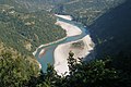 Gandaki River Valley in Palpa
 Gandaki River Valley in Palpa
 Ranighat Palace
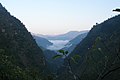 Mahabharat Range, Lesser Himalaya
 Mountains around Tansen
 Glades around Tansen
 View of Palpa Madifaat ( rice field) & Damkada City during summer time
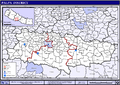 Map of Palpa District


Places of attraction
- Argali Palace was constructed by Juddha Shamsher
- Forts like Kalika fort, Nuwakot fort, Bakumgadi Fort are historic place of attraction
- Mahamritunjaya Statue of Lord Shiva situated at Barangdi which is the biggest in Asia among metal statue of Lord Shiva
- Rambha Devi Temple a religious place 31 km (19 mi) east of Tansen in Tahu VDC.
- Ramdi is a religious place in the bank of Kali Gandaki River. On 1 Baisakh, there is a festival in this area.
- Ranighat Palace (Ranimahal) is also called Tajmahal of Nepal due to similar stories behind the construction of this palace. It was constructed by General Khadka for her wife Tejkumari in 1893 AD.
- Rishikesh Complex of Ruru Kshetra Hindu pilgrimage and cremation site
- Rishikesh Temple was built by the King Manimukunda Sen. According to Hindu mythology, this is the place where some part of body of Satidevei was cremated. It hosts a festival which occurs in 1st of Magh month when hidus come to take bath in Kali Gandaki River.
- Shrinagar Hill is spot for viewing high Himalayas. Dhawalagiri, Tukuche, Nilgiri, Annapurana, Himchuli and other mountains can be viewed from this place.
- Tansen is a historic city with palaces, temples, stupas and historic architecture.
- Vhairabsthan Temple is a Shiva temple with huge trident, believed to be largest in Asia.
- Madanpokhara is known its vegetable farmings and viewing great Madi Valley.[citation needed]
Remove ads
Villages
See also
References
External links
Wikiwand - on
Seamless Wikipedia browsing. On steroids.
Remove ads