Top Qs
Timeline
Chat
Perspective
Plessur Alps
From Wikipedia, the free encyclopedia

Remove ads
The Plessur Alps are a mountain range in the Alps of eastern Switzerland and are considered to be part of the Western Rhaetian Alps. They are named after the river Plessur, which originates from the center of the ranges. The Plessur Alps are separated from the Glarus Alps in the west by the Rhine valley; from the Rätikon range in the north by the Landquart river valley (Prättigau); from the Albula Alps in the south-east by the Landwasser river valley; from the Oberhalbstein Alps in the south by the Albula river valley.

The Plessur Alps are drained by the rivers Rhine, Plessur, Landwasser and Landquart. The Arosa ski resort lies in the middle of the range.
Peaks of the Plessur Alps are the Aroser Rothorn (highest, 2,980 m (9,780 ft)) and Stätzerhorn (2,576 m (8,451 ft)).
The 2,377-metre (7,799 ft) Strela Pass is one of the major mountain passes in the range, and runs from Davos to Langwies.
Remove ads
Peaks
Summarize
Perspective
The chief peaks of the Plessur Alps are listed below.
Remove ads
Gallery
 Lake near Arosa
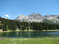
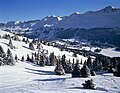
 Valley of Lenzerheide
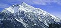
 Parpaner Rothorn (right)
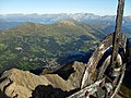 Summit of Lenzerhorn

.jpg)


References
- Swisstopo maps
Wikimedia Commons has media related to Plessur Range.
Wikiwand - on
Seamless Wikipedia browsing. On steroids.
Remove ads