Top Qs
Timeline
Chat
Perspective
Pracuúba
Place in North, Brazil From Wikipedia, the free encyclopedia
Remove ads
Pracuúba (Portuguese pronunciation: [pɾakuˈubɐ]) is a municipality located in the mideast of the state of Amapá in Brazil. It became an independent municipality in 1992.[1] The town can be accessed from the BR-156 highway.[2]
Remove ads
Geography
The population of Pracuúba is 5,246[3] and its area is 4,957 square kilometres (1,914 sq mi). Pracuúba is located 235 kilometres (146 mi) from the state capitol of Macapá. The name of the municipality comes from a tree common to the area known as the pracuubeira. The economy of Pracuúba relies of artisanal fishing and raising livestock, primarily buffalo. It also produces timber and açaí.[4]
The municipality contains part of the 392,469 hectares (969,810 acres) Lago Piratuba Biological Reserve, a fully protected conservation unit created in 1980.[5] It also contains 4.52% of the 2,369,400 hectares (5,855,000 acres) Amapá State Forest, a sustainable use conservation unit established in 2006.[6] It contains 52.85% of the 460,353 hectares (1,137,560 acres) Amapá National Forest, a sustainable use conservation unit created in 1989.[7]
Remove ads
Cujubim
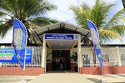
Cujubim is an agricultural village located in the municipality. Pedro Maciel Filho, a native of Cujubim, wanted a school in his village where agricultural techniques were taught. Filho donated land on which the school could be constructed.[8] On 9 January 2021, the Pedro Maciel Filho School was opened in Cujubim.[9]
See also
References
External links
Wikiwand - on
Seamless Wikipedia browsing. On steroids.
Remove ads


