Top Qs
Timeline
Chat
Perspective
Solomianskyi District
Urban district in Kyiv in Kyiv Municipality, Ukraine From Wikipedia, the free encyclopedia

Remove ads
The Solomianskyi District[a] is a district in Kyiv, the capital of Ukraine. Located in the western part of the city, in the basin of Lybid river, Dniepr's tributary. Named after village of Solomianka that became part of Kyiv in 1858. Established as a district in 1921. Reogarnized in 2001. An area of the district was settled since the Middle Ages. The so-called mount of Batu Khan who invaded Kyiv in 1240 is located within the district.


.svg)
Remove ads
Population
Language
Distribution of the population by native language according to the 2001 census:[1]
Neighbourhoods
- Hrushky (Грушки) — hamlet of the 19th century. During 1871–1902 it belonged to nobleman K. Hrushko (hence got its name).
- Karavaievi Dachi (Караваєві Дачі, "Karavaiev's cottages") — area of border outposts outside of Kyiv in the XII—XIII c. In 1872 it was purchased by Russian doctor Vladimir Karavayev.
- Vidradnyi Відрадний
- Shuliavka (Шулявка) — mentioned under 1146 in the Hypatian Codex. In the 18th century this area was a residence of the Orthodox metropolitan bishops of Kyiv.
- Batyieva Hora (Батиєва Гора) - former village, now historical neighbourhood, where Batyievi caves, remains of the Zarubyntsi culture, were found
Remove ads
Education
Gallery
 Solomianska Street looking east
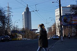 Solomianska street, with the Kyiv Court of Appeals building in the background
 Protasiv Yar Street
 Traffic junction at Sevastopolska Square


Notes
- Ukrainian: Соло́м'янський райо́н, romanized: Solómʺyansʹkyi raión, IPA: [soˈlɔmjɐnʲsʲkɪj rɐˈjɔn]
- Those who did not indicate their native language or indicated a language that was native to less than 1% of the local population.
References
External links
Wikiwand - on
Seamless Wikipedia browsing. On steroids.
Remove ads