Top Qs
Timeline
Chat
Perspective
St Aldate's, Oxford
Street in central Oxford, England From Wikipedia, the free encyclopedia
Remove ads
St Aldate's (/ˈɔːldeɪtz/ AWL-daytz) is a street in central Oxford, England,[1][2] named after Saint Aldate, but formerly known as Fish Street.[3]


Museum and Church
The street runs south from the generally acknowledged centre of Oxford at Carfax. The Town Hall, which includes the Museum of Oxford, is on the east side of the street. Christ Church, with its imposing Tom Tower, faces the east end of St Aldate's, while Pembroke College (on Pembroke Square) faces its west end. Other adjoining streets include Blue Boar Street to the east side and Pembroke Street, Pembroke Square, Brewer Street, Rose Place, and Speedwell Street to the west. St Aldate's Church is on the west side of the street, in Pembroke Square.
Remove ads
Alice's Shop
Opposite Christ Church is Alice's Shop, formerly frequented by Alice Liddell, and the model for the Sheep Shop in the "Wool and Water" chapter in Through the Looking-Glass.[4]

Old Palace (Bishop King's Palace)
The Old Palace, Nos. 86 & 87, St Aldates is a range of buildings dating from the early 17th century, although incorporating earlier works. The main block is a three-storey timber-framed structure. Later additions were made in the 19th century. It is now the headquarters for the Oxford University Catholic Chaplaincy and a Grade I listed building.[5]
Bate Collection of Musical Instruments
South of Christ Church is an entrance to Christ Church Meadow and, still on the east side, the University of Oxford's Faculty of Music, containing the Bate Collection of Musical Instruments; the building was opened in 1936 for St Catherine's Society. Oxford's police station (designed by H. F. Hurcombe, the City Estates Surveyor, and completed in 1936)[1] and the Oxford Combined Court Centre (designed by Henry Smith and completed in 1932)[6] opposite precede a junction with Thames Street to the west.
Remove ads
Continuation into Abingdon Road
After Folly Bridge over the River Thames or Isis, St Aldate's enters Grandpont and becomes Abingdon Road (A4144), leading directly south out of the city of Oxford towards the Oxford Ring Road and the villages of Kennington and Radley and the town of Abingdon.
Gallery
 The northern end of St Aldate's.
 Alice's Shop on St Aldate's, opposite Christ Church.
 Tom Tower and the main entrance to Christ Church, the largest Oxford college, on St Aldate's.
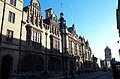 Oxford Town Hall on St Aldate's.
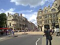 The High and Cornmarket streets intersection at the far northern end of St Aldate's.
 St Aldate's Street from the Speedwell Street entrance, adjacent to the Bate Collection of Musical Instruments in Christ Church Park.
 View of St Aldate's longing north from Folly Bridge with The Head of the River public house on the right.
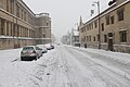 Looking south down St Aldate's in the snow, with Christ Church on the left.
 St Aldate's Church, which gives the street its name
 A view of St Aldate's Tavern from across the road.


.JPG)


Remove ads
References
External links
Wikiwand - on
Seamless Wikipedia browsing. On steroids.
Remove ads