Top Qs
Timeline
Chat
Perspective
Parish of St Andrew
Cadastral in New South Wales, Australia From Wikipedia, the free encyclopedia

Remove ads
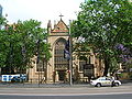
St Andrew Parish, Cumberland is one of the 57 parishes of Cumberland County, New South Wales, a cadastral unit for use on land titles. It is one of the four small parishes in the Sydney city area (together with St Philip, St Lawrence and St James), and is named after the church of St Andrew's. The parish was named while the church was still in the planning stages. The parish includes Pyrmont and the Darling Harbour area. It is bounded by Wattle Street in the south west, George Street in the south and east, and King Street in the north-east.[1] It includes Town Hall railway station, which is on the eastern end of the parish.
Remove ads
Locations
Images of locations in the parish:
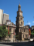
 The Queen Victoria Building at the eastern end of the parish
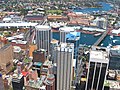 Buildings in the Darling Harbour area; most of this land is in the Parish of St Andrew except for Wentworth Park and the land beyond it.
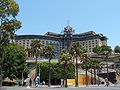
 The University of Technology is located on the southern end of the parish.


Remove ads
References
Wikiwand - on
Seamless Wikipedia browsing. On steroids.
Remove ads