Top Qs
Timeline
Chat
Perspective
Steinhöfel
Municipality in Brandenburg, Germany From Wikipedia, the free encyclopedia

Remove ads
Steinhöfel is a municipality in the Oder-Spree district, in Brandenburg, Germany. Since the beginning of 2019 it belongs to the collective municipality "Amt Odervorland"


The contemporary municipality of Steinhöfel comprises a total of twelve physical villages, namely Steinhöfel, Arensdorf, Beerfelde, Buchholz, Demnitz, Gölsdorf, Hasenfelde, Heinersdorf, Jänickendorf, Neuendorf im Sande, Schönfelde and Tempelberg.[3]
Remove ads
History
Summarize
Perspective
In 1774, the Prussian Minister of War and Treasury[4] Joachim von Blumenthal purchased the estate of Steinhöfel, including a manor that was later expanded into a castle. When von Blumenthal died, the estate was inherited by his daughter Charlotte von Massow, whose husband the Court Marshal Valentin von Massow commissioned a rebuilding of the manor by the architect David Gilly. The property was inherited in turn by the couple's son Valentin von Massow who had served with Wellington in Spain and as one of his adjutants at Waterloo.
During the Seven Years' War, the castle's surroundings saw a brief visit by Frederick the Great resting his troops prior to the Battle of Kunersdorf. Later recreational visitors included Frederick William III of Prussia and Theodor Fontane who expressed considerable enthusiasm about the place.
The castle (de:Schloß Steinhöfel) today hosts a hotel and commercial venue under Cultural heritage regulations.
From 1815 to 1947, Steinhöfel was part of the Prussian Province of Brandenburg, from 1947 to 1952 of the State of Brandenburg, from 1952 to 1990 of the Bezirk Frankfurt of East Germany and since 1990 again of Brandenburg.
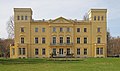 The castle as seen from the park side
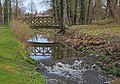 landscaped garden
 Demnitz (Steinhöfel), Village Lutheran Church
 Neuendorf im Sande (Steinhöfel), village church


_Dorfkirche.jpg)
Remove ads
Demography
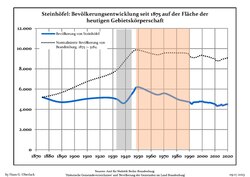 Development of population since 1875 within the current Boundaries (Blue Line: Population; Dotted Line: Comparison to Population development in Brandenburg state; Grey Background: Time of Nazi Germany; Red Background: Time of communist East Germany)
 Recent Population Development and Projections (Population Development before Census 2011 (blue line); Recent Population Development according to the Census in Germany in 2011 (blue bordered line); Official projections for 2005-2030 (yellow line); for 2014-2030 (red line); for 2017-2030 (scarlet line)


Remove ads
References
Wikiwand - on
Seamless Wikipedia browsing. On steroids.
Remove ads