Top Qs
Timeline
Chat
Perspective
Suō Province
Historical province in Japan From Wikipedia, the free encyclopedia
Remove ads
Suō Province (周防国, Suō no Kuni; Japanese pronunciation: [sɯꜜ.oː (no kɯ.ɲi)][1]) was a province of ancient Japan in the area that is today the eastern part of Yamaguchi Prefecture.[2] Suō bordered on Aki, Iwami, and Nagato Provinces.

Its abbreviated form name was Bōshū (防州). In terms of the Gokishichidō system, Suō was one of the provinces of the San'yōdō circuit. Under the Engishiki classification system, Suō was ranked as one of the "superior countries" (上国) in terms of importance, and one of the "far countries" (遠国) in terms of distance from the imperial capital, Kyoto. The provincial capital was located in what is now the city of Hōfu, Yamaguchi. The ichinomiya of the province is the Tamanooya Shrine also located in Hōfu. [3]

Remove ads
History
Summarize
Perspective
Before the establishment of the Ritsuryō system, the area of Suō was under control of various semi-independent kuni no miyatsuko: Ōshima Kuni (Suō-Ōshima), Suō Kuni (Kumage County, Kuga County), Hakuki Kuni (Kishiki County), Tsunu Kuni (Tono County), and Sawa Kuni (Sawa County) . These were united to form the Ritsuryo province, which initially consisted of five counties: Oshima, Kumage, Tsuno, Sawa, and Kisiki. Kuga County was divided from Kumage in 721 to form the sixth counties. In the Asuka period, the Iwakisan Kōgoishi mountain fortification was constructed against a possible invasion by Tang dynasty China and the Kingdom of Silla in Korean peninsula. Wooden tally strips bearing the name of 'Suho Province', 'Shuyō Province' and 'Suō Province' have been found at the ruins of Fujiwara-kyō and Heijō-kyō and the names were used interchangeably in Nara period records, such as the Nihon Shoki.
During the Kamakura period, the ruling Hōjō clan were the shugo of the province, and were replaced in the Muromachi period by the Ōuchi clan. During the Sengoku period, the Mōri clan supplanted the Ōuchi, and the province became part of the holdings of Chōshū Domain in the Edo Period. Following the Meiji restoration, the province became part of Yamaguchi Prefecture. The area of former Suo Province is now divided between the cities of Hōfu, Kudamatsu, Iwakuni, Hikari, Yanai, Shūnan, Ōshima District, Kuga District, Kumage District, and most of Yamaguchi city (excluding the former Ato Town), and a portion of Ube.
Remove ads
Meiji period
Following the Meiji restoration, Suō was divided into six districts. [4] Per the early Meiji period Kyudaka kyuryo Torishirabe-chō (旧高旧領取調帳), an official government assessment of the nation’s resources, the province had 295 villages with a total kokudaka of 548,861 koku.
Remove ads
Gallery
 Tamanooya Shrine, ichinomiya of the province
 Ruins of Suo Kokubun-ji
 Ruins of Suo Kokuga
 Iwakuni Castle
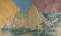 Shōhō Kuniezu - Suō Province, with Nagato in yellow, Iwami in blue, and Aki in pink (Yamaguchi Prefectural Archives)
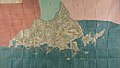 Genroku Kuniezu - Suō Province, with Nagato in red, Iwami in green, and Aki in pink (Yamaguchi Prefectural Archives)
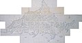 Tenpō Kuniezu - Suō Province (Yamaguchi Prefectural Archives)
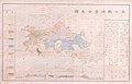 1878 map of Yamaguchi Prefecture, marked with its two constituent provinces of Suō (周防) and Nagato (長門), as well as neighbouring Iwami (石見) and Aki (安藝) (Yamaguchi Prefectural Archives)
,_shaden.jpg)


.jpg)
.jpg)
.jpg)
.jpg)
Notes
References
External links
Wikiwand - on
Seamless Wikipedia browsing. On steroids.
Remove ads