Top Qs
Timeline
Chat
Perspective
Tōkai-Hokuriku Expressway
Expressway in Japan From Wikipedia, the free encyclopedia

Remove ads
The Tōkai-Hokuriku Expressway (東海北陸自動車道, Tōkaihokuriku Jidōsha-dō) is a national expressway in the Chūbu region on the island of Honshū in Japan. It is managed by Central Nippon Expressway Company. The route is signed E41 under the Ministry of Land, Infrastructure, Transport and Tourism's "2016 Proposal for Realization of Expressway Numbering."[3]

Remove ads
Overview
Summarize
Perspective
Tōkai and Hokuriku are the names of the two regions of Japan that are linked by the expressway.
The expressway begins at a junction with the Meishin Expressway to the northwest of the Nagoya urban area and follows a northerly course into Gifu Prefecture, passing the capital Gifu and heading further north into the mountainous Hida region. The expressway also passes by Shirakawa-gō and Gokayama, two UNESCO World Heritage Sites straddling the border between Gifu Prefecture and Toyama Prefecture. The expressway continues north through western Toyama Prefecture to its terminus at a junction with the Hokuriku Expressway and the Nōetsu Expressway.
The first section of the expressway was opened to traffic in 1986. The final section of the expressway (25 km between Hida-Kiyomi Interchange and Shirakawagō Interchange) was opened on July 5, 2008.[1] A major component of this section is the Hida Tunnel, the second longest road tunnel in Japan[4] after the Kan-Etsu Tunnel. A total of 1.22 trillion yen was spent on planning and construction of the expressway over 36 years.[5]
The expressway is 4 lanes from Ichinomiya Junction to Fukubegatake Parking Area, and 2 lanes on all other sections. Construction to expand the route to 4 lanes is currently underway on the section between Fukubegatake Parking Area and Shirotori Interchange.[6] The speed limit is 80 km/h on 4-laned sections and 70 km/h on 2-laned sections.[1]
Remove ads
Features
At 1,086 meters, Matsunoki Pass between Shōkawa Interchange and Hida-Kiyomi Interchange is the highest point in the national expressway network.[7] A parking area is planned to open at this point.
There are a total of 54 tunnels either completed or under construction. After the Hida Tunnel, the Hakamagoshi Tunnel (between Fukumitsu Interchange and Gokayama Interchange) is the longest. Trucks carrying hazardous materials are forbidden from using the tunnel and must use alternate routes.
The piers on the Washimi Bridge (between Shōkawa Interchange and Takasu Interchange) are the tallest in Japan, at 118 m.[8]
Remove ads
List of interchanges and features
This article contains a bulleted list or table of intersections which should be presented in a properly formatted junction table. (November 2021) |
- IC - interchange, SIC - smart interchange, JCT - junction, SA - service area, PA - parking area, BS - bus stop, TN - tunnel, BR - bridge
Remove ads
Gallery
 Ichinomiya Junction southbound
 Bisai Interchange
 Near Kawashima Parking Area
 Bridge over the Kiso River
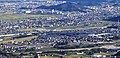 Mino-Seki Junction southbound
 Gujō-Hachiman Bus Stop
 Construction work to expand to 4 lanes near Gifu-Yamato Interchange
 Near Takasu Interchange
 Washimi Bridge
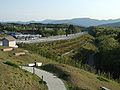 View from Hiruganokōgen Service Area facing south
 Pacific Ocean-Japan Sea watershed boundary near Hiruganokōgen Service Area
 Future site of Matsunokitōge Parking Area
 Hida-Kiyomi Interchange
 Near Shirakawagō Interchange
 View from Jōhana Service Area facing north


Remove ads
References
External links
Wikiwand - on
Seamless Wikipedia browsing. On steroids.
Remove ads