Top Qs
Timeline
Chat
Perspective
Transylvanian Plain
Ethnogeographical area in Romania From Wikipedia, the free encyclopedia
Remove ads
The Transylvanian Plain (Romanian: Câmpia Transilvaniei; Hungarian: Mezőség, lit. 'plain area') is an ethnogeographical area in Transylvania, Romania, located between the Someșul Mare and the Someșul Mic rivers to the north and west and the Mureș River to the south and east. It is populated by both ethnic Romanians and ethnic Hungarians.

The Transylvanian Plain can be divided into two parts: a hilly one in the northeast and a flatter one in the south and west.
Important villages in the Transylvanian Plain include Sic (in Hungarian, Szék; a former salt-mining town), Mociu (Mócs), Jucu (Zsuk), Band (Mezőbánd), Suatu (Magyarszovát), and Unguraș (Bálványosváralja).
Remove ads
Images
 Reformed Church in Beclean
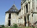
 Ceuașu de Câmpie Reformed church and bell tower
 Răscruci Banffy castle
 Câmpenița Reformed Church
 Kornis Castle în Mănăstirea
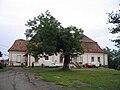 Voivodeni castle


This Romanian location article is a stub. You can help Wikipedia by expanding it. |
This Romania-related article is a stub. You can help Wikipedia by expanding it. |
Remove ads
Wikiwand - on
Seamless Wikipedia browsing. On steroids.
Remove ads