Top Qs
Timeline
Chat
Perspective
Vaiʻava Strait
From Wikipedia, the free encyclopedia

Remove ads
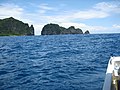
Vaiʻava Strait (Samoan: Vāinuʻu o Vaiʻava) is a narrow strait in Vatia, American Samoa which separates the 420-foot-high (130 m) Pola Island (Cock's Comb) from Polauta Ridge on adjacent Tutuila Island. The strait is a good example of cliffs formed by the erosional forces of waves on volcanic rock. The lands surrounding the strait are held communally. A 250-acre (100 ha) area surrounding the strait was designated a U.S. National Natural Landmark in 1972.[1] It is also a part of the National Park of American Samoa.
.png)

Pola-Uta is connected to the village of Vatia on Tutuila Island. Pola Tai is a 400-foot (120 m) cliff that is an important nesting area for the fuaʻō (brown booby) and tavaʻe (white tailored tropic bird). Hunting of brown boobies, known as the Aʻega o le Pola, was a tradition carried out by Vatians in the past. Pola Tai includes Matalia Point, Cockscomb Point and Polauta Ridge.[2][3][4]
Remove ads
Gallery
 Vaiʻava Strait, 1907
 Eastern point of Vatia Bay
 Polauta Ridge and Pola Island


See also
References
External links
Wikiwand - on
Seamless Wikipedia browsing. On steroids.
Remove ads