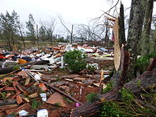
2013 Hattiesburg tornado
Tornado in Mississippi, United StatesIn the afternoon hours of February 10, 2013, a large multiple-vortex tornado devastated the cities of West Hattiesburg, Hattiesburg, and Petal, Mississippi. The tornado was one of eight that touched down in southern Mississippi and southwestern Alabama that day. It reached a maximum path width of 0.75 miles (1.21 km) in its path through the Hattiesburg area and reached estimated maximum sustained winds of 170 mph (270 km/h) in Oak Grove neighborhood of West Hattiesburg. It destroyed many structures and impacted University of Southern Mississippi and two high schools. Mississippi was declared a federal disaster area by President Barack Obama, and a state of emergency was issued by Mississippi Governor Phil Bryant.
Read article
Top Questions
AI generatedMore questions
Nearby Places

M. M. Roberts Stadium
American football stadium

Reed Green Coliseum
Multi-purpose sports arena in Mississippi, United States
University of Southern Mississippi
Public university in Hattiesburg, Mississippi, US
Fay B. Kaigler Children's Book Festival

Hattiesburg Zoo
Zoo in Hattiesburg, Mississippi

Aubrey K. Lucas Administration Building
Building on the campus of the University of Southern Mississippi in the US

McCain Library and Archives
Chief reserve library for The University of Southern Mississippi, United States
WFOR (AM)
Sports radio station in Hattiesburg, Mississippi


