Map Graph

Aegean Sea

Mediterranean between Greece and Turkey

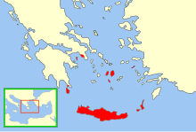
The Aegean Sea is an elongated embayment of the Mediterranean Sea between Europe and Asia. It is located between the Balkans and Anatolia, and covers an area of some 215,000 km2 (83,000 sq mi). In the north, the Aegean is connected to the Marmara Sea, which in turn connects to the Black Sea, by the straits of the Dardanelles and the Bosphorus, respectively. The Aegean Islands are located within the sea and some bound it on its southern periphery, including Crete and Rhodes. The sea reaches a maximum depth of 2,639 m to the west of Karpathos. The Thracian Sea and the Sea of Crete are main subdivisions of the Aegean Sea.

Read article
File:Aegean_Sea_map.pngFile:Location_of_the_Aegean_Sea.pngFile:Greece_map_of_Köppen_climate_classification_(new).svgFile:Skyscrapers_in_Izmir_-_Turkey.jpgFile:Acropolis_wide_view.jpgFile:White_Tower_and_Beach_front.jpgFile:Bodrum_Castle_(2017).jpgFile:Cycladic_figurine,_female,_2800-2300_BC,_AM_Naxos_(13_01),_143205.jpgFile:Greek_Galleys.jpgFile:Celcius_library.jpgFile:Emirate_of_Crete_Map.svgFile:Aegean_Sea_by_Piri_Reis.jpgFile:German_tanks_in_Rhodes.gifFile:Chora_of_Mykonos_(9).jpg
Top Questions
AI generated

List the top facts about Aegean Sea

Summarize this article

What is the single most intriguing fact about Aegean Sea?

Are there any controversies surrounding Aegean Sea?

More questions
Timeline
AI Generated
  • 4000 BCThe current coastline of the Aegean Sea dates back to approximately this time.
  • 3000 BCThe Minoan civilization begins to flourish on Crete and other Aegean islands.
  • 1600 BCThe rise of Mycenaean Greeks, the first advanced civilization in mainland Greece.
Show full timeline