No coordinates found
Arabia Petraea
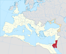
Roman province (106–630s)Arabia Petraea was a Roman province from the 2nd century to the 7th century. It was established after the Roman Empire conquered the Nabataean Kingdom in 106 and existed until the Muslim conquest of the Levant in the 630s. Spanning much of the Sinai Peninsula and part of the Levant, it was bordered by Syria to the north, by Judea to the west, and by Egypt to the southwest. To the east and southeast of Arabia Petraea was non-Roman territory that the Romans knew as Arabia Deserta. These two regions, together with a third region in South Arabia that was called Arabia Felix, accounted for the Arabian Peninsula in Roman geography.
Read article
Top Questions
AI generatedMore questions


