Barnegat Bay
Bay in New JerseyBarnegat Bay is a small brackish arm of the Atlantic Ocean, approximately 42 miles (68 km) long, along the coast of Ocean County, New Jersey in the United States. It is separated from the Atlantic by the long Island Beach State Park, as well as by the north end of Long Beach Island, popular segments of the Jersey Shore. The bay is fed by several small rivers, including the Toms River, the Forked River, the Metedeconk River, Cedar Creek, Oyster Creek, Mill Creek, Westecunk Creek, and Tuckerton Creek, all of which empty into the bay through small estuaries along its inner shore. The communities of Toms River, Silverton, and Forked River sit along the river estuaries on the bay.
Read article


Top Questions
AI generatedMore questions
Nearby Places

Forked River, New Jersey
Place in Ocean County, New Jersey, United States
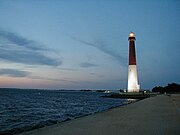
Barnegat Lighthouse
Lighthouse in New Jersey, United States
Lanoka Harbor, New Jersey
Place in Ocean County, New Jersey, United States
Murray Grove

Barnegat Inlet
Inlet in New Jersey
Island Beach, New Jersey
Borough in New Jersey, United States
Tices Shoal
Island Beach (barrier island)