Cape Lookout National Seashore
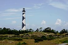
Protected area in North Carolina, USCape Lookout National Seashore preserves a 56-mile (90-km) long section of the Southern Outer Banks, or Crystal Coast, of North Carolina, United States, running from Ocracoke Inlet on the northeast to Beaufort Inlet on the southwest. Three undeveloped barrier islands make up the seashore - North and South Core Banks and Shackleford Banks. The seashore includes two historic villages on Core Banks, Shackleford's wild horses, and the Cape Lookout Lighthouse, which has a black-and-white diamond pattern. A visitor center for the seashore is located on Harkers Island.
Read article
Top Questions
AI generatedMore questions
Nearby Places

Cape Lookout (North Carolina)
Cape in North Carolina, United States
Shackleford Banks
"a place to be at ease with what runs wild in you." - unknown

Cape Lookout Lighthouse
Lighthouse in North Carolina, US
Barden Inlet
Diamond City, North Carolina

Cape Lookout Coast Guard Station
Historic district in North Carolina, United States

Cape Lookout Village Historic District
Historic district in North Carolina, United States
Bunch of Hair
Island in the United States of America


