Cape Fear River
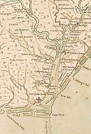
River in North Carolina, United StatesThe Cape Fear River is a 191.08-mile-long (307.51-kilometer) blackwater river in eastern North Carolina. It flows into the Atlantic Ocean near Cape Fear, from which it takes its name. The river is formed at the confluence of the Haw River and the Deep River in the town of Moncure, North Carolina. Its river basin is the largest in the state: 9,149 sq mi.
Read article


Top Questions
AI generatedMore questions
Nearby Places

Bald Head Island, North Carolina
Village in North Carolina, United States
CSS North Carolina
Ironclad gunboat built by the Confederate States Navy in 1863

Oak Island Light
Lighthouse in North Carolina, US

Bald Head Light
Lighthouse in North Carolina, US

Hatch Auditorium
Assembly hall owned by the North Carolina Baptist Assembly
Battle of Cape Fear River (1718)
1718 naval battle in the Cape Fear River

Oak Island Life Saving Station
United States historic place

Fort Caswell Historic District
Historic district in North Carolina, United States