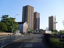
Castlemilk
District of Glasgow, ScotlandCastlemilk is a district of Glasgow, Scotland. It lies to the far south of the city centre, adjacent to the Croftfoot and Simshill residential areas within the city to the north-west, the town of Rutherglen - neighbourhoods of Spittal to the north-east and Fernhill to the east, Linn Park and its golf course to the west, and the separate village of Carmunnock further south across countryside.
Read article
Top Questions
AI generatedMore questions
Nearby Places

Croftfoot
Human settlement in Scotland

Simshill
St Margaret Mary's Secondary School
Comprehensive secondary school in Castlemilk, Glasgow , Scotland
Castlemilk High School
Comprehensive school in Glasgow , Scotland
Bogany Flats
Residential in Glasgow, Scotland

Linn Park, Glasgow
200 acre park in Glasgow, Scotland
King's Park Secondary School
Secondary school in Glasgow, Lanarkshire, Scotland

Castlemilk House
Country house in Glasgow, Scotland


